MIT Libraries logoDome

MIT
View Item 
  • Dome Home
  • Visual Collections
  • Boston Suburbs Project
  • View Item
  • Dome Home
  • Visual Collections
  • Boston Suburbs Project
  • View Item
JavaScript is disabled for your browser. Some features of this site may not work without it.

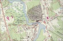
U.S. Geological Survey Map of Billerica Garden Suburb in North Billerica, Massachusetts

Geological Survey (U.S.)
Thumbnail
Download150844_cp.jpg (1.155Mb)
Alternate file
150844_sv.jpg (1.602Mb)
150844_tm.jpg (24.07Kb)
URI
http://hdl.handle.net/1721.3/158659
Description
detail
Type of Work
Map
Subject
Suburbs, Topographic maps, Housing developments, Massachusetts -- Maps, Geological Survey (U.S.), Billerica (Mass.), Massachusetts -- Maps, Geological Survey (U.S.), Boston Suburbs - Chapter 3 - 1910-1920
Rights
(c) Massachusetts Institute of Technology, photograph by Julie Johnson
Rights Statement
All rights reserved
Item is Part of
141830
Metadata
Show full item record

Collections
  • Boston Suburbs Project

Browse

All of DomeCommunities & CollectionsBy Issue DateCreatorsTitlesSubjectsThis CollectionBy Issue DateCreatorsTitlesSubjects

My Account

Login
MIT Libraries
PrivacyPermissionsAccessibilityContact us
MIT
Content created by the MIT Libraries, CC BY-NC unless otherwise noted. Notify us about copyright concerns.