| dc.coverage.spatial | Site: starts in Fort Kent (Maine, United States) | en_US |
| dc.coverage.spatial | Site: ends in Key West (Florida, United States) | en_US |
| dc.coverage.temporal | creation date: formed, 1926 | en_US |
| dc.creator | Massachusetts. Department of Transportation | en_US |
| dc.date | 1926 | en_US |
| dc.date.accessioned | 2014-03-04T16:44:59Z | |
| dc.date.available | 2014-03-04T16:44:59Z | |
| dc.date.issued | 1926 | en_US |
| dc.identifier | 140774 | en_US |
| dc.identifier.uri | http://hdl.handle.net/1721.3/160230 | |
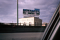
| dc.description | general view, Boston Globe newspaper sign seen from Route 1, 1987 | en_US |
| dc.relation.ispartof | 139414 | en_US |
| dc.rights | (c) Massachusetts Institute of Technology, photograph by Lois A. Craig | en_US |
| dc.subject | Highways | en_US |
| dc.subject | Roads | en_US |
| dc.subject | Transportation | en_US |
| dc.subject | United States Highway 1 | en_US |
| dc.subject | Signs | en_US |
| dc.subject | Boston Suburbs - Chapter 5 - 1940-1960 | en_US |
| dc.title | United States Highway 1 | en_US |
| dc.title.alternative | United States Route 1 | en_US |
| dc.type | Image | en_US |
| dc.rights.access | Creative Commons Attribution-NonCommercial 3.0 http://creativecommons.org/licenses/by-nc/3.0/ | en_US |
| dc.identifier.vendorcode | 5.235 | en_US |
| vra.culturalContext | American | en_US |
| vra.worktype | Highway | en_US |
| dc.contributor.display | Government agency: Massachusetts. Department of Transportation | en_US |