MIT Libraries logoDome

MIT
View Item 
  • Dome Home
  • Visual Collections
  • Boston Suburbs Project
  • View Item
  • Dome Home
  • Visual Collections
  • Boston Suburbs Project
  • View Item
JavaScript is disabled for your browser. Some features of this site may not work without it.

Massachusetts Route 128

Massachusetts. Dept. of Public Works
Thumbnail
Download140719_cp.jpg (589.3Kb)
Alternate file
140719_sv.jpg (2.710Mb)
140719_tm.jpg (27.89Kb)
Alternative Titles
Yankee Division Highway
Circumferential Highway
URI
http://hdl.handle.net/1721.3/160175
Date
1927
Description
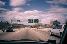
Route 128, opened as a four lane highway 1951; first multi-lane circumferential highway in metropolitan area; located at a 10-mile radius from Boston.
 
general view, highway signs: North 128; Exits 25-24-23 - Interstate 90, Route 30 - Mass. Pike Next Right; Exit 22 - Grove St. M.B.T.A. Sta., 1987
 
Type of Work
Highway
Subject
Highways, Suburbs, Transportation, Beltways, Massachusetts Route 128 (Mass.), Signs, Newton (Mass.), Boston Suburbs - Chapter 5 - 1940-1960
Rights
(c) Massachusetts Institute of Technology, photograph by Lois A. Craig
Rights Statement
Creative Commons Attribution-NonCommercial 3.0 http://creativecommons.org/licenses/by-nc/3.0/
Item is Part of
139404
Metadata
Show full item record

Collections
  • Boston Suburbs Project

Browse

All of DomeCommunities & CollectionsBy Issue DateCreatorsTitlesSubjectsThis CollectionBy Issue DateCreatorsTitlesSubjects

My Account

Login
MIT Libraries
PrivacyPermissionsAccessibilityContact us
MIT
Content created by the MIT Libraries, CC BY-NC unless otherwise noted. Notify us about copyright concerns.