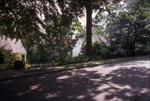
| dc.coverage.spatial | Site: Brookline (Massachusetts, United States) | en_US |
| dc.coverage.temporal | creation date: Olmsted plan, 1880, creation date: Bowditch plan, 1883, creation date: Aspinwall Hill Land Company plan, 1885 | en_US |
| dc.creator | Olmsted, Frederick Law | en_US |
| dc.creator | Bowditch, Ernest W. | en_US |
| dc.creator | Aspinwall Hill Land Company | en_US |
| dc.date | 1880 | en_US |
| dc.date.accessioned | 2014-01-31T21:24:17Z | |
| dc.date.available | 2014-01-31T21:24:17Z | |
| dc.date.issued | 1880 | en_US |
| dc.identifier | 159027 | en_US |
| dc.identifier.uri | http://hdl.handle.net/1721.3/157412 | |
| dc.description | Curving road layout to accommodate hill site and earlier plan for hilltop park. | en_US |
| dc.description | general view, shady street, houses, 1987 | en_US |
| dc.relation.ispartof | 141160 | en_US |
| dc.rights | (c) Massachusetts Institute of Technology | en_US |
| dc.subject | Suburbs | en_US |
| dc.subject | Architecture, Modern --19th century | en_US |
| dc.subject | Housing developments | en_US |
| dc.subject | Architecture, Domestic --United States | en_US |
| dc.subject | Brookline (Mass.) | en_US |
| dc.subject | Residential districts | en_US |
| dc.subject | Houses | en_US |
| dc.subject | Streets | en_US |
| dc.subject | Single-family dwellings | en_US |
| dc.subject | Boston Suburbs - Chapter 2 - 1865-1910 | en_US |
| dc.title | Aspinwall Hill | en_US |
| dc.type | Image | en_US |
| dc.rights.access | Creative Commons Attribution-NonCommercial 3.0 http://creativecommons.org/licenses/by-nc/3.0/ | en_US |
| dc.identifier.vendorcode | 2.625 | en_US |
| vra.culturalContext | American | en_US |
| vra.worktype | Housing development | en_US |
| dc.contributor.display | planner: original plan by Frederick Law Olmsted (American, 1822-1903), planner: revised plan by Ernest W. Bowditch (American, active 1891-1899), developer: Aspinwall Hill Land Company (American, active late 19th century) | en_US |


