| dc.coverage.spatial | Site: Baltimore (Maryland, United States) | en_US |
| dc.creator | American | en_US |
| dc.date.accessioned | 2011-03-03T15:34:58Z | |
| dc.date.available | 2011-03-03T15:34:58Z | |
| dc.date.issued | 1729 | |
| dc.identifier | 157304 | en_US |
| dc.identifier.uri | http://hdl.handle.net/1721.3/60918 | en_US |
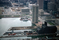
| dc.description | aerial view, view west over pier 3 and 4 area, world's tallest equal sided pentagonal building (I. M. Pei, 1977) (future World Trade Center Institute), and sloop-of-war U.S.S. Constellation - prior development of Inner Harbor, April 1978 | en_US |
| dc.relation.ispartof | 137926 | en_US |
| dc.rights | © Alex S. MacLean / Landslides | en_US |
| dc.subject | Urban planning | en_US |
| dc.subject | Ports | en_US |
| dc.subject | Land use, Urban | en_US |
| dc.subject | City planning | en_US |
| dc.subject | Cities and towns -- United States | en_US |
| dc.subject | Sailing ships | en_US |
| dc.subject | Warships | en_US |
| dc.subject | Piers | en_US |
| dc.subject | Parking lots | en_US |
| dc.subject | High-rise buildings | en_US |
| dc.subject | Pentagons | en_US |
| dc.subject | Waterfronts | en_US |
| dc.subject | Urban development | en_US |
| dc.subject | Inner Harbor (Baltimore, Md.) | en_US |
| dc.subject | Power-plants | en_US |
| dc.subject | Aerial photography | en_US |
| dc.title | City of Baltimore | en_US |
| dc.type | Image | en_US |
| dc.rights.access | Licensed for educational and research use by the MIT community only | en_US |
| dc.identifier.vendorcode | 455-3 | en_US |
| vra.culturalContext | American | en_US |
| vra.technique | construction | en_US |
| vra.worktype | City | en_US |
| dc.contributor.display | American | en_US |


