MIT Libraries logoDome

MIT
View Item 
  • Dome Home
  • Visual Collections
  • Aerial Photography
  • View Item
  • Dome Home
  • Visual Collections
  • Aerial Photography
  • View Item
JavaScript is disabled for your browser. Some features of this site may not work without it.

City of Baltimore

American
Thumbnail
Download157304_cp.jpg (892.5Kb)
Alternate file
157304_sv.jpg (1.077Mb)
157304_tm.jpg (20.78Kb)
URI
http://hdl.handle.net/1721.3/60918
Date
1729
Description
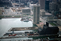
aerial view, view west over pier 3 and 4 area, world's tallest equal sided pentagonal building (I. M. Pei, 1977) (future World Trade Center Institute), and sloop-of-war U.S.S. Constellation - prior development of Inner Harbor, April 1978
Type of Work
City
Subject
Urban planning, Ports, Land use, Urban, City planning, Cities and towns -- United States, Sailing ships, Warships, Piers, Parking lots, High-rise buildings, Pentagons, Waterfronts, Urban development, Inner Harbor (Baltimore, Md.), Power-plants, Aerial photography
Rights
© Alex S. MacLean / Landslides
Rights Statement
Licensed for educational and research use by the MIT community only
Item is Part of
137926
Metadata
Show full item record

Collections
  • Aerial Photography

Browse

All of DomeCommunities & CollectionsBy Issue DateCreatorsTitlesSubjectsThis CollectionBy Issue DateCreatorsTitlesSubjects

My Account

Login
MIT Libraries
PrivacyPermissionsAccessibilityContact us
MIT
Content created by the MIT Libraries, CC BY-NC unless otherwise noted. Notify us about copyright concerns.