| dc.coverage.temporal | creation date: field work finished, May 1913, publication date: 1915 | en_US |
| dc.creator | Munn, Leonard | en_US |
| dc.date | May 1913 | en_US |
| dc.date.accessioned | 2009-11-17T16:46:51Z | |
| dc.date.available | 2009-11-17T16:46:51Z | |
| dc.date.issued | 1913 | en_US |
| dc.identifier | 112932 | en_US |
| dc.identifier.uri | http://hdl.handle.net/1721.3/45355 | en_US |
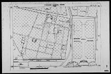
| dc.description | full view, Jahan Numa Risala Road; Jahan Numa Road; and Bagh Jahan Numa Bashir-ud-duala Br.
visible | en_US |
| dc.format.medium | paper (fiber product) | en_US |
| dc.format.medium | ink | en_US |
| dc.relation.ispartof | 131641 | en_US |
| dc.subject | Cartography | en_US |
| dc.subject | Maps | en_US |
| dc.subject | Urban planning | en_US |
| dc.subject | Islamic cities and towns | en_US |
| dc.subject | Architecture, Islamic --India | en_US |
| dc.subject | Surveys | en_US |
| dc.subject | Historical geography --Maps | en_US |
| dc.subject | Hyderabad (India) | en_US |
| dc.title | Sheet no. 106, City Area | en_US |
| dc.type | Image | en_US |
| dc.identifier.vendorcode | 39080013433302 | en_US |
| dc.publisher.institution | Repository: Rotch Library, Massachusetts Institute of Technology (Cambridge,
Massachusetts, United States) | en_US |
| vra.culturalContext | Indian (South Asian) | en_US |
| vra.technique | cartography | en_US |
| vra.technique | surveying | en_US |
| vra.worktype | Map | en_US |
| dc.contributor.display | surveyor: Leonard Munn (English, 1878-1935) | en_US |


