Browsing Perceptual Form of the City by Subject "Industrial buildings"
Now showing items 1-20 of 23
-
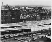
Central Artery, Boston Harbor in Background
(Repository: Rotch Visual Collections, Massachusetts Institute of Technology (Cambridge, Massachusetts, United States) ID: Kepes/Lynch Collection, 59.04, 1956) -
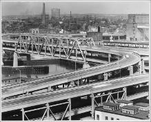
Central Artery, Charlestown in Background
(Repository: Rotch Visual Collections, Massachusetts Institute of Technology (Cambridge, Massachusetts, United States) ID: Kepes/Lynch Collection, 59.03, 1954-1959) -
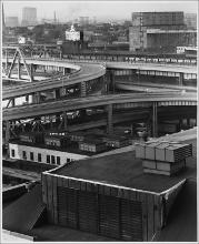
Central Artery, Industrial Structures Background and Foreground
(Repository: Rotch Visual Collections, Massachusetts Institute of Technology (Cambridge, Massachusetts, United States) ID: Kepes/Lynch Collection, 59.02, 1956) -
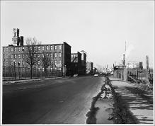
Grid Series, Taken from Intersecting Points of Map, Albany Street, 2:10 P.M.
(Repository: Rotch Visual Collections, Massachusetts Institute of Technology (Cambridge, Massachusetts, United States) ID: Kepes/Lynch Collection, 51.27, 1954-1959) -
Grid Series, Taken from Intersecting Points of Map, Albany Street, Facing North, 2:30 P.M.
(Repository: Rotch Visual Collections, Massachusetts Institute of Technology (Cambridge, Massachusetts, United States) ID: Kepes/Lynch Collection, 51.39, 1954-1959) -
Grid Series, Taken from Intersecting Points of Map, Albany Street, Facing Northeast
(Repository: Rotch Visual Collections, Massachusetts Institute of Technology (Cambridge, Massachusetts, United States) ID: Kepes/Lynch Collection, 51.55, 1956) -
Grid Series, Taken from Intersecting Points of Map, Clinton Street and Revere Avenue, Frontier Produce Co., 11:15 A.M.
(Repository: Rotch Visual Collections, Massachusetts Institute of Technology (Cambridge, Massachusetts, United States) ID: Kepes/Lynch Collection, 51.18, 1954-1959) -
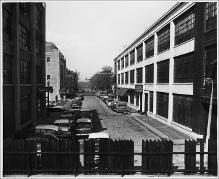
Grid Series, Taken from Intersecting Points of Map, Construction Site, Fort Point Channel Area, Facing Gillette Factory
(Repository: Rotch Visual Collections, Massachusetts Institute of Technology (Cambridge, Massachusetts, United States) ID: Kepes/Lynch Collection, 51.56, 1956) -
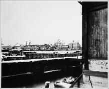
Grid Series, Taken from Intersecting Points of Map, Docks off Commercial Street
(Repository: Rotch Visual Collections, Massachusetts Institute of Technology (Cambridge, Massachusetts, United States) ID: Kepes/Lynch Collection, 51.31, 1954-1959) -
Grid Series, Taken from Intersecting Points of Map, Dorchester Avenue, 3:45 P.M.
(Repository: Rotch Visual Collections, Massachusetts Institute of Technology (Cambridge, Massachusetts, United States) ID: Kepes/Lynch Collection, 51.23, 1954-1959) -
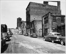
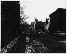
Grid Series, Taken from Intersecting Points of Map, Empty Lot between Randolf and Thayer Streets
(Repository: Rotch Visual Collections, Massachusetts Institute of Technology (Cambridge, Massachusetts, United States) ID: Kepes/Lynch Collection, 51.32, 1956) -
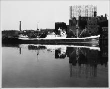
Grid Series, Taken from Intersecting Points of Map, Fort Point Avenue from Dorchester Avenue, Cargo Ship, 3:30 P.M.
(Repository: Rotch Visual Collections, Massachusetts Institute of Technology (Cambridge, Massachusetts, United States) ID: Kepes/Lynch Collection, 51.22, 1954-1959) -
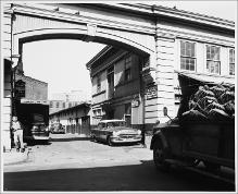
Grid Series, Taken from Intersecting Points of Map, Lewis Wharf, Boston Tow Boat Company, 10:45 A.M.
(Repository: Rotch Visual Collections, Massachusetts Institute of Technology (Cambridge, Massachusetts, United States) ID: Kepes/Lynch Collection, 51.43, 1954-1959) -
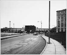
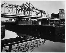
Grid Series, Taken from Intersecting Points of Map, Nashua Street, Facing Northeast towards Railway Bridge
(Repository: Rotch Visual Collections, Massachusetts Institute of Technology (Cambridge, Massachusetts, United States) ID: Kepes/Lynch Collection, 51.37, 1954-1959) -
Grid Series, Taken from Intersecting Points of Map, Plympton Street, Holy Cross Cathedral in Background
(Repository: Rotch Visual Collections, Massachusetts Institute of Technology (Cambridge, Massachusetts, United States) ID: Kepes/Lynch Collection, 51.50, 1956) -
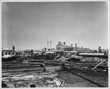
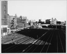
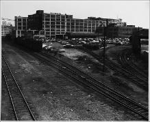
Grid Series, Taken from Intersecting Points of Map, Railroad Tracks, South Boston
(Repository: Rotch Visual Collections, Massachusetts Institute of Technology (Cambridge, Massachusetts, United States) ID: Kepes/Lynch Collection, 51.58, 1954-1959) -
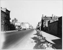
Grid Series, Taken from Intersecting Points of Map, Stoughton Street, 2:05 P.M.
(Repository: Rotch Visual Collections, Massachusetts Institute of Technology (Cambridge, Massachusetts, United States) ID: Kepes/Lynch Collection, 51.11, 1954-1959) -
Grid Series, Taken from Intersecting Points of Map, View of Broadway Bridge from Albany Street, 3:20 P.M.
(Repository: Rotch Visual Collections, Massachusetts Institute of Technology (Cambridge, Massachusetts, United States) ID: Kepes/Lynch Collection, 51.21, 1954-1959) -
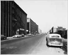
Parking Area, Between Frigidaire Appliances and Hub Distributors Shipping, Blandford Street
(Repository: Rotch Visual Collections, Massachusetts Institute of Technology (Cambridge, Massachusetts, United States) ID: Kepes/Lynch Collection, 60.30, 1957) -
Parking Lot next to Train Tracks, S. S. Pierce Co., Brookline Avenue
(Repository: Rotch Visual Collections, Massachusetts Institute of Technology (Cambridge, Massachusetts, United States) ID: Kepes/Lynch Collection, 60.19, 1957)