| dc.coverage.spatial | Publication location: London (England) | en_US |
| dc.coverage.temporal | creation date: 1775 | en_US |
| dc.creator | Page, Thomas Hyde, Sir | en_US |
| dc.date | 1775 | en_US |
| dc.date.accessioned | 2008-11-06T16:14:43Z | |
| dc.date.available | 2008-11-06T16:14:43Z | |
| dc.date.issued | 1775 | en_US |
| dc.identifier | 125692 | en_US |
| dc.identifier.uri | http://hdl.handle.net/1721.3/29635 | en_US |
| dc.description | full view | en_US |
| dc.format.medium | paper (fiber product) | en_US |
| dc.format.medium | ink | en_US |
| dc.relation.ispartof | 135994 | en_US |
| dc.rights | public domain | en_US |
| dc.subject | United States --History --Revolution, 1775-1783 | en_US |
| dc.subject | Armies | en_US |
| dc.subject | Cartography | en_US |
| dc.subject | Imperialism | en_US |
| dc.subject | Boston (Mass.) | en_US |
| dc.subject | Cambridge (Mass.) | en_US |
| dc.subject | United States --History --Colonial period, ca. 1600-1775 | en_US |
| dc.subject | Historical geography --Maps | en_US |
| dc.subject | Land use, Urban | en_US |
| dc.subject | Surveying | en_US |
| dc.subject | Roxbury (Boston, Mass.) | en_US |
| dc.subject | Brookline (Mass.) | en_US |
| dc.subject | Dorchester (Boston, Mass.) | en_US |
| dc.subject | South Boston (Boston, Mass.) | en_US |
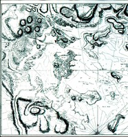
| dc.title | Boston, its Environs and Harbour with the Rebels Works raised against that Town in 1775, from the Observations of Lieutenant Page of His Majesty's Corps of Engineers | en_US |
| dc.title.alternative | Lieutenant Page's Map of Boston | en_US |
| dc.type | Image | en_US |
| dc.rights.access | In the Public Domain; no use restrictions | en_US |
| vra.culturalContext | British | en_US |
| vra.culturalContext | American | en_US |
| vra.technique | engraving (incising) | en_US |
| vra.technique | printing | en_US |
| vra.worktype | Map | en_US |
| dc.contributor.display | surveyor: Sir Thomas Hyde Page (British, 1746-1821) | en_US |


