Boston, its Environs and Harbour with the Rebels Works raised against that Town in 1775, from the Observations of Lieutenant Page of His Majesty's Corps of Engineers

Download125692_cp.jpg (406.9Kb)
Alternative Title
Lieutenant Page's Map of Boston
Date
1775Description
full view
Type of Work
MapSubject
United States --History --Revolution, 1775-1783, Armies, Cartography, Imperialism, Boston (Mass.), Cambridge (Mass.), United States --History --Colonial period, ca. 1600-1775, Historical geography --Maps, Land use, Urban, Surveying, Roxbury (Boston, Mass.), Brookline (Mass.), Dorchester (Boston, Mass.), South Boston (Boston, Mass.)
Rights
Rights Statement
In the Public Domain; no use restrictions
Item is Part of
135994
Metadata
Show full item recordCollections
Related items
Showing items related by title, author, creator and subject.
-
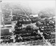
Aerial View Looking South, Copley Square, South End
(Repository: Rotch Visual Collections, Massachusetts Institute of Technology (Cambridge, Massachusetts, United States) ID: Kepes/Lynch Collection, 40.28, 1957) -
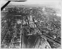
Aerial View from Plane, Looking East, Boylston Street to Intersection with Huntington Avenue, Large Rail Yard, John Hancock Building, Boston Skyline and Harbor in Background
(Repository: Rotch Visual Collections, Massachusetts Institute of Technology (Cambridge, Massachusetts, United States) ID: Kepes/Lynch Collection, 40.06, 1957) -
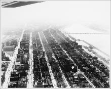
Aerial View, Back Bay, Copley Square, Looking Southwest, Commonwealth Avenue, Charles River
(Repository: Rotch Visual Collections, Massachusetts Institute of Technology (Cambridge, Massachusetts, United States) ID: Kepes/Lynch Collection, 40.09, 1957)