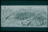
| dc.coverage.temporal | Creation date: 1471-1482 | en_US |
| dc.creator | Rosselli, Francesco di Lorenzo | en_US |
| dc.date | 1471-1482 | en_US |
| dc.date.accessioned | 2008-01-15T20:26:01Z | |
| dc.date.available | 2008-01-15T20:26:01Z | |
| dc.date.issued | 1471-1482 | en_US |
| dc.identifier | 108543 | en_US |
| dc.identifier.uri | http://hdl.handle.net/1721.3/23961 | en_US |
| dc.description | full view | en_US |
| dc.format.medium | ink | en_US |
| dc.relation.ispartof | 111929 | en_US |
| dc.rights | (c) Carnegie Slide Collection | en_US |
| dc.subject | Cartography | en_US |
| dc.subject | Florence (Italy) | en_US |
| dc.subject | Italy --History --1268-1492 | en_US |
| dc.subject | Historical geography --Maps | en_US |
| dc.subject | Land use, Urban | en_US |
| dc.subject | Art, Renaissance | en_US |
| dc.title | Della Catena Map of Florence | en_US |
| dc.type | Image | en_US |
| dc.rights.access | Licensed for educational and research use by the MIT community
only | en_US |
| vra.culturalContext | Italian | en_US |
| vra.technique | etching (corroding) | en_US |
| vra.technique | cartography | en_US |
| vra.worktype | Map, Panorama | en_US |
| dc.contributor.display | cartographer: Francesco di Lorenzo Rosselli (Italian, 1445-1513) | en_US |


