MIT Libraries logoDome

MIT
View Item 
  • Dome Home
  • Visual Collections
  • Architecture, Urban Planning, and Visual Arts
  • View Item
  • Dome Home
  • Visual Collections
  • Architecture, Urban Planning, and Visual Arts
  • View Item
JavaScript is disabled for your browser. Some features of this site may not work without it.

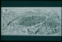
Della Catena Map of Florence

Rosselli, Francesco di Lorenzo
Thumbnail
Download108543_cp.jpg (408.1Kb)
Alternate file
108543_sv.jpg (962.6Kb)
108543_tm.jpg (29.76Kb)
URI
http://hdl.handle.net/1721.3/23961
Date
1471-1482
Description
full view
Type of Work
Map, Panorama
Subject
Cartography, Florence (Italy), Italy --History --1268-1492, Historical geography --Maps, Land use, Urban, Art, Renaissance
Rights
(c) Carnegie Slide Collection
Rights Statement
Licensed for educational and research use by the MIT community only
Item is Part of
111929
Metadata
Show full item record

Collections
  • Architecture, Urban Planning, and Visual Arts

Browse

All of DomeCommunities & CollectionsBy Issue DateCreatorsTitlesSubjectsThis CollectionBy Issue DateCreatorsTitlesSubjects

My Account

Login
MIT Libraries
PrivacyPermissionsAccessibilityContact us
MIT
Content created by the MIT Libraries, CC BY-NC unless otherwise noted. Notify us about copyright concerns.