| dc.coverage.temporal | creation date: original map that study is based on, 1772, creation date: HUDA study, late 20th century | en_US |
| dc.creator | Hyderabad Urban Development Authority | en_US |
| dc.date | 1772 | en_US |
| dc.date.accessioned | 2007-10-26T20:50:53Z | |
| dc.date.available | 2007-10-26T20:50:53Z | |
| dc.date.issued | 1772 | en_US |
| dc.identifier | 112290 | en_US |
| dc.identifier.uri | http://hdl.handle.net/1721.3/22045 | en_US |
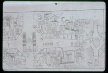
| dc.description | map, section of sheet 1, showing the lay out of the neighborhoods with Charminar in the center left, 1986 | en_US |
| dc.format.medium | paper (fiber product) | en_US |
| dc.format.medium | ink | en_US |
| dc.relation.ispartof | 131501 | en_US |
| dc.rights | (c) Rahul Mehrotra 1986 | en_US |
| dc.subject | Cartography | en_US |
| dc.subject | Conservation | en_US |
| dc.subject | Islamic cities and towns | en_US |
| dc.subject | Architecture, Islamic --India | en_US |
| dc.subject | Historical geography --Maps | en_US |
| dc.subject | Urban planning and environment | en_US |
| dc.subject | Hyderabad (India) | en_US |
| dc.subject | Deccan (India) | en_US |
| dc.title | Urban Conservation Study, Map of Hyderabad City | en_US |
| dc.type | Image | en_US |
| dc.rights.access | All rights reserved | en_US |
| dc.identifier.vendorcode | 19-31 | en_US |
| dc.publisher.institution | Repository: original map that HUDA study is based on, Idarah-i Adabiyat-i Urdu (Hyderabad, Andhra Pradesh, India) | en_US |
| vra.culturalContext | Indian (South Asian) | en_US |
| vra.culturalContext | Islamic | en_US |
| vra.technique | cartography | en_US |
| vra.worktype | Map | en_US |
| dc.contributor.display | cartographer: Hyderabad Urban Development Authority (Indian (South Asian), 1975-) | en_US |


