| dc.coverage.spatial | Creation location: Hyderabad (Andhra Pradesh, India) | en_US |
| dc.creator | City Improvement Board | en_US |
| dc.creator | Fayyazuddin, Muhammad | en_US |
| dc.date.accessioned | 2007-08-21T18:47:12Z | |
| dc.date.available | 2007-08-21T18:47:12Z | |
| dc.identifier | 109538 | en_US |
| dc.identifier.uri | http://hdl.handle.net/1721.3/20030 | en_US |
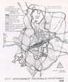
| dc.description | full view, showing City Improvement Board proposal for development of roads, railway line, residential areas, public buildings, parks, graveyards, city wall and municipal boundary based on M. Visvesvarayya's report. | en_US |
| dc.format.medium | paper (fiber product) | en_US |
| dc.format.medium | ink | en_US |
| dc.relation.ispartof | 130037 | en_US |
| dc.subject | Cartography | en_US |
| dc.subject | India | en_US |
| dc.subject | Islamic cities and towns | en_US |
| dc.subject | Historical geography --Maps | en_US |
| dc.subject | Land use, Urban | en_US |
| dc.subject | City planning | en_US |
| dc.subject | Urban planning and environment | en_US |
| dc.subject | Hyderabad (India) | en_US |
| dc.title | Hyderabad City Improvement Proposal | en_US |
| dc.type | Image | en_US |
| dc.rights.access | All rights reserved | en_US |
| vra.culturalContext | Indian (South Asian) | en_US |
| vra.technique | cartography | en_US |
| vra.worktype | Map | en_US |
| dc.contributor.display | cartographer: City Improvement Board (Indian (South Asian), 1912-ca. 1962), urban planner: Muhammad Fayyazuddin (Indian (South Asian), 1903-1977) | en_US |