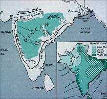
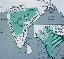
Map of India Showing the Deccan Plateau
| dc.creator | Alam, Manzoor | en_US |
| dc.date.accessioned | 2007-08-21T18:46:47Z | |
| dc.date.available | 2007-08-21T18:46:47Z | |
| dc.identifier | 109528 | en_US |
| dc.identifier.uri | http://hdl.handle.net/1721.3/20028 | en_US |
| dc.description | full view, with inset of rainfall figures | en_US |
| dc.format.medium | paper (fiber product) | en_US |
| dc.format.medium | ink | en_US |
| dc.relation.ispartof | 130015 | en_US |
| dc.rights | (c) Manzoor Alam | en_US |
| dc.subject | Cartography | en_US |
| dc.subject | India | en_US |
| dc.subject | Maps | en_US |
| dc.subject | Rain and rainfall | en_US |
| dc.subject | Plateaus (landforms) | en_US |
| dc.subject | Topographic maps | en_US |
| dc.subject | Southeast Asia | en_US |
| dc.title | Map of India Showing the Deccan Plateau | en_US |
| dc.type | Image | en_US |
| dc.rights.access | All rights reserved | en_US |
| vra.culturalContext | Indian (South Asian) | en_US |
| vra.technique | cartography | en_US |
| vra.worktype | Map | en_US |
| dc.contributor.display | cartographer: Manzoor Alam (Indian (South Asian), 20th century-) | en_US |
Files in this item
This item appears in the following Collection(s)
-
Architecture in Hyderabad, India
Images and maps documenting the architectural history of Hyderabad, India


