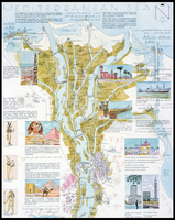
Map of Fatimid Cairo, after the Official State Plan of the Survey Office
| dc.coverage.spatial | creation location: Cairo (Egypt) | en_US |
| dc.coverage.temporal | creation date: 1950 | en_US |
| dc.creator | unknown (Egyptian (modern)) | en_US |
| dc.date | 1950 | en_US |
| dc.date.accessioned | 2007-04-30T15:37:01Z | |
| dc.date.available | 2007-04-30T15:37:01Z | |
| dc.date.issued | 1950 | en_US |
| dc.identifier | 105464 | en_US |
| dc.identifier.uri | http://hdl.handle.net/1721.3/18143 | en_US |
| dc.description | map | en_US |
| dc.format.medium | paper (fiber product) | en_US |
| dc.format.medium | ink | en_US |
| dc.relation.ispartof | 129667 | en_US |
| dc.subject | Cairo (Egypt) | en_US |
| dc.subject | Egypt -- Description and travel | en_US |
| dc.subject | Fatimid | en_US |
| dc.subject | Islamic cities and towns | en_US |
| dc.subject | Architecture, Islamic --Egypt | en_US |
| dc.subject | Historical geography --Maps | en_US |
| dc.subject | Land use, Urban | en_US |
| dc.subject | Egypt --Maps | en_US |
| dc.subject | Monuments --Egypt | en_US |
| dc.subject | Cities and towns --Egypt | en_US |
| dc.title | Map of Fatimid Cairo, after the Official State Plan of the Survey Office | en_US |
| dc.type | Image | en_US |
| dc.rights.access | All rights reserved | en_US |
| vra.culturalContext | Egyptian (modern) | en_US |
| vra.culturalContext | Islamic | en_US |
| vra.technique | cartography | en_US |
| vra.worktype | Map | en_US |
| dc.contributor.display | unknown (Egyptian (modern)) | en_US |
Files in this item


This item appears in the following Collection(s)
-
Architecture, Urban Planning, and Visual Arts
Online Image Collection
Related items
Showing items related by title, author, creator and subject.
-
Darb al-Ahmar
(909-1171) -
Darb al-Ahmar
(909-1171)