MIT Libraries logoDome

MIT
View Item 
  • Dome Home
  • Visual Collections
  • Architecture, Urban Planning, and Visual Arts
  • View Item
  • Dome Home
  • Visual Collections
  • Architecture, Urban Planning, and Visual Arts
  • View Item
JavaScript is disabled for your browser. Some features of this site may not work without it.

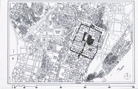
Map of Fatimid Cairo, after the Official State Plan of the Survey Office

unknown (Egyptian (modern))
Thumbnail
Download105464_cp.jpg (362.8Kb)
Alternate file
105464_sv.jpg (1.604Mb)
105464_tm.jpg (37.18Kb)
URI
http://hdl.handle.net/1721.3/18143
Date
1950
Description
map
Type of Work
Map
Subject
Cairo (Egypt), Egypt -- Description and travel, Fatimid, Islamic cities and towns, Architecture, Islamic --Egypt, Historical geography --Maps, Land use, Urban, Egypt --Maps, Monuments --Egypt, Cities and towns --Egypt
Rights Statement
All rights reserved
Item is Part of
129667
Metadata
Show full item record

Collections
  • Architecture, Urban Planning, and Visual Arts

Related items

Showing items related by title, author, creator and subject.
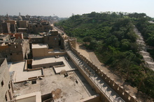
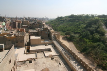
  • Thumbnail

    Tourist Map of Nile River Showing Sites of Interest 

    unknown (undetermined)
  • Thumbnail

    Darb al-Ahmar 

    Aga Khan Trust for Culture. Historic Cities Programme (909-1171)
  • Thumbnail

    Darb al-Ahmar 

    Aga Khan Trust for Culture. Historic Cities Programme (909-1171)

Browse

All of DomeCommunities & CollectionsBy Issue DateCreatorsTitlesSubjectsThis CollectionBy Issue DateCreatorsTitlesSubjects

My Account

Login
MIT Libraries
PrivacyPermissionsAccessibilityContact us
MIT
Content created by the MIT Libraries, CC BY-NC unless otherwise noted. Notify us about copyright concerns.