Hyderabad Municipal Survey
| dc.coverage.temporal | creation date: surveyed, 1912-1915, publication date: 1915 | en_US |
| dc.creator | Munn, Leonard | en_US |
| dc.date | 1912-1915 | en_US |
| dc.date.accessioned | 2015-08-28T18:27:06Z | |
| dc.date.available | 2015-08-28T18:27:06Z | |
| dc.date.issued | 1912-1915 | en_US |
| dc.identifier | 259220 | en_US |
| dc.identifier.uri | http://hdl.handle.net/1721.3/173928 | |
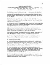
| dc.description | Index to the KARWAN MAPS, Area 11, 1-48 (missing 3, 4, 5, 6, 11, 12, 16, 19, 24, 25, 27, 28, 29, 31, 32, 33, 34, 36). Compiled by Karen Leonard, 2015 | en_US |
| dc.format.medium | paper (fiber product) | en_US |
| dc.format.medium | ink | en_US |
| dc.relation.ispartof | 130722 | en_US |
| dc.rights | (c) Karen Leonard | en_US |
| dc.subject | Cartography | en_US |
| dc.subject | Maps | en_US |
| dc.subject | Urban planning | en_US |
| dc.subject | Islamic cities and towns | en_US |
| dc.subject | Architecture, Islamic --India | en_US |
| dc.subject | Surveys | en_US |
| dc.subject | Historical geography --Maps | en_US |
| dc.subject | Hyderabad (India) | en_US |
| dc.title | Hyderabad Municipal Survey | en_US |
| dc.type | Image | en_US |
| dc.rights.access | All rights reserved | en_US |
| dc.identifier.vendorcode | KARWAN MAPS | en_US |
| vra.culturalContext | Indian (South Asian) | en_US |
| vra.technique | cartography | en_US |
| vra.technique | surveying | en_US |
| vra.worktype | Land survey, Map | en_US |
| dc.contributor.display | surveyor: Leonard Munn (English, 1878-1935) | en_US |
Files in this item
This item appears in the following Collection(s)
-
Architecture in Hyderabad, India
Images and maps documenting the architectural history of Hyderabad, India