MIT Libraries logoDome

MIT
View Item 
  • Dome Home
  • Visual Collections
  • Architecture, Urban Planning, and Visual Arts
  • View Item
  • Dome Home
  • Visual Collections
  • Architecture, Urban Planning, and Visual Arts
  • View Item
JavaScript is disabled for your browser. Some features of this site may not work without it.

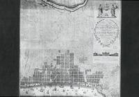
Plan of the Cities and Suburbs of Philadelphia

Folie, A. P.
Thumbnail
Download105636_cp.jpg (203.2Kb)
Alternate file
105636_sv.jpg (815.7Kb)
105636_tm.jpg (34.40Kb)
URI
http://hdl.handle.net/1721.3/17107
Description
full view
Type of Work
Plan (map)
Subject
Suburbs, Urban planning, Grids (layout features), Plans (drawings), Urbanization, Historical geography --Maps, Cities and towns --Growth, Land use, Urban, City planning, Drawing --18th century, Philadelphia (Pa.)
Rights Statement
All rights reserved
Item is Part of
129548
Metadata
Show full item record

Collections
  • Architecture, Urban Planning, and Visual Arts

Browse

All of DomeCommunities & CollectionsBy Issue DateCreatorsTitlesSubjectsThis CollectionBy Issue DateCreatorsTitlesSubjects

My Account

Login
MIT Libraries
PrivacyPermissionsAccessibilityContact us
MIT
Content created by the MIT Libraries, CC BY-NC unless otherwise noted. Notify us about copyright concerns.