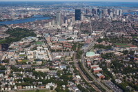
MIT Libraries logoDome

MIT
View Item 
  • Dome Home
  • Visual Collections
  • Aerial Photography
  • View Item
  • Dome Home
  • Visual Collections
  • Aerial Photography
  • View Item
JavaScript is disabled for your browser. Some features of this site may not work without it.

Mission Hill

American
Thumbnail
Download247684_cp.jpg (733.3Kb)
Alternate file
247684_sv.jpg (2.346Mb)
247684_tm.jpg (23.24Kb)
Alternative Title
Parker HIll
URI
http://hdl.handle.net/1721.3/162859
Date
1868
Description
aerial view, looking northeast along Southeast Corridor, 9/14/2009
Type of Work
Neighborhood
Subject
Urban planning, Boston (Mass.), Neighborhoods, Urban areas, Land use, Urban, City planning, National Register of Historic Places, Aerial views, Central business districts, Aerial photography --United States
Rights
© Alex S. MacLean / Landslides
Rights Statement
Licensed for educational and research use by the MIT community only
Item is Part of
144017
Metadata
Show full item record

Collections
  • Aerial Photography

Browse

All of DomeCommunities & CollectionsBy Issue DateCreatorsTitlesSubjectsThis CollectionBy Issue DateCreatorsTitlesSubjects

My Account

Login
MIT Libraries
PrivacyPermissionsAccessibilityContact us
MIT
Content created by the MIT Libraries, CC BY-NC unless otherwise noted. Notify us about copyright concerns.