MIT Libraries logoDome

MIT
View Item 
  • Dome Home
  • Visual Collections
  • Aerial Photography
  • View Item
  • Dome Home
  • Visual Collections
  • Aerial Photography
  • View Item
JavaScript is disabled for your browser. Some features of this site may not work without it.

Dorchester

American
Thumbnail
Download246868_cp.jpg (606.6Kb)
Alternate file
246868_sv.jpg (1.791Mb)
246868_tm.jpg (22.68Kb)
URI
http://hdl.handle.net/1721.3/161983
Date
1630
Description
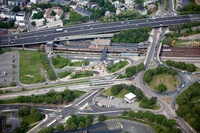
aerial view, Route 1/Interstate 93, top, JFK/UMass MBTA Red Line Station, 10/9/2013
Type of Work
Neighborhood
Subject
Urban planning, Boston (Mass.), Neighborhoods, Urban areas, Land use, Urban, City planning, Highways, Aerial views, Traffic circles, Massachusetts Bay Transportation Authority, Aerial photography --United States
Rights
© Alex S. MacLean / Landslides
Rights Statement
Licensed for educational and research use by the MIT community only
Item is Part of
143857
Metadata
Show full item record

Collections
  • Aerial Photography

Browse

All of DomeCommunities & CollectionsBy Issue DateCreatorsTitlesSubjectsThis CollectionBy Issue DateCreatorsTitlesSubjects

My Account

Login
MIT Libraries
PrivacyPermissionsAccessibilityContact us
MIT
Content created by the MIT Libraries, CC BY-NC unless otherwise noted. Notify us about copyright concerns.