| dc.coverage.spatial | Site: Chicago (Illinois, USA) | en_US |
| dc.creator | Burnham, Daniel Hudson | en_US |
| dc.creator | Bennett, Edward Herbert | en_US |
| dc.date.accessioned | 2007-01-30T21:48:23Z | |
| dc.date.available | 2007-01-30T21:48:23Z | |
| dc.identifier | 101341 | en_US |
| dc.identifier.uri | http://hdl.handle.net/1721.3/15642 | en_US |
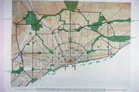
| dc.description | full view, general map showing topography, waterways, and complete system of streets boulevards, parkways, and parks | en_US |
| dc.relation.ispartof | 100553 | en_US |
| dc.subject | Chicago (Ill.) | en_US |
| dc.subject | Visionary architecture | en_US |
| dc.subject | Urban planning | en_US |
| dc.subject | Plans (drawings) | en_US |
| dc.subject | Cities and towns --Growth | en_US |
| dc.subject | Land use, Urban | en_US |
| dc.title | Burnham-Bennett Plan of Chicago | en_US |
| dc.type | Image | en_US |
| dc.rights.access | All rights reserved | en_US |
| vra.culturalContext | American | en_US |
| vra.worktype | Plan (map) | en_US |
| dc.contributor.display | architect: Daniel Hudson Burnham (American, 1846-1912), architect: Edward Herbert Bennett (American, 1874-1954) | en_US |


