| dc.coverage.temporal | creation date: 1850s | en_US |
| dc.creator | Vincent, Edward A. | en_US |
| dc.date | 1850s | en_US |
| dc.date.accessioned | 2012-06-08T13:53:15Z | |
| dc.date.available | 2012-06-08T13:53:15Z | |
| dc.date.issued | 1850-1859 | en_US |
| dc.identifier | 135078 | en_US |
| dc.identifier.uri | http://hdl.handle.net/1721.3/81325 | en_US |
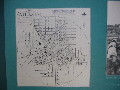
| dc.description | comparative material, reproduction of map in Atlanta Underground Visitors' Center, 2003 | en_US |
| dc.format.extent | 72 x 72 cm (28.35 x 28.35 inches) | en_US |
| dc.format.medium | paper (fiber product) | en_US |
| dc.format.medium | ink | en_US |
| dc.relation.ispartof | 138607 | en_US |
| dc.rights | (c) Özgür Basak Alkan 2003 | en_US |
| dc.subject | Cartography | en_US |
| dc.subject | Historical geography --Maps | en_US |
| dc.subject | City planning | en_US |
| dc.subject | Atlanta (Ga.) | en_US |
| dc.subject | Cadastral maps | en_US |
| dc.title | Vincent's subdivision map of the city of Atlanta, Dekalb County, state of Georgia : showing all the lots, blocks, sections, &c. | en_US |
| dc.type | Image | en_US |
| dc.rights.access | All rights reserved | en_US |
| dc.identifier.vendorcode | IMG_7319_OzgurBasakAlkan.JPG | en_US |
| dc.publisher.institution | Repository: Library of Congress (Washington, District of Columbia, United States) ID: G3924.A8 185- .V5 | en_US |
| vra.culturalContext | American | en_US |
| vra.technique | cartography | en_US |
| vra.worktype | Map | en_US |
| dc.contributor.display | cartographer: Edward A. Vincent (American, 19th century) | en_US |