
Plaza de Santa Domingo
Download1A2-M-MC-PS-A2_cp.jpg (506.8Kb)
Date
2013-01-25Description
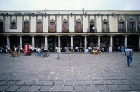
Santo Domingo in Mexico City refers to the Church of Santo Domingo and its Plaza, also called Santo Domingo. Due to its style, the Baroque church (1717-1736) is attributed to Pedro de Arrieta. Both are located three blocks north of the Mexico City Metropolitan Cathedral following Republica de Brasil Street with Belisario Dominguez Street separating the two. To the south of the church is Plaza San Domingo. It is flanked to the west by the Portal de Evangelistas, which is a Tuscan colonnade with round arches. The land on the east side of Santo Domingo Plaza was given to Captain Don Cristobal de Oñate, Gonzalo de Salazar and the Marquis of Villamayor soon after the Conquest on which all built residences. This property had been greatly damaged by the flood in 1629, which had made 75% of the buildings in the city uninhabitable for some time. Despite this, the site was chosen for the Royal Customs Office in 1729.; Santo Domingo in Mexico City refers to the Church of Santo Domingo and its Plaza, also called Santo Domingo. Due to its style, the Baroque church (1717-1736) is attributed to Pedro de Arrieta. Both are located three blocks north of the Mexico City Metropolitan Cathedral following Republica de Brasil Street with Belisario Dominguez Street separating the two. To the south of the church is Plaza San Domingo. It is flanked to the west by the Portal de Evangelistas, which is a Tuscan colonnade with round arches. The land on the east side of Santo Domingo Plaza was given to Captain Don Cristobal de Oñate, Gonzalo de Salazar and the Marquis of Villamayor soon after the Conquest on which all built residences. This property had been greatly damaged by the flood in 1629, which had made 75% of the buildings in the city uninhabitable for some time. Despite this, the site was chosen for the Royal Customs Office in 1729. Source: Wikipedia; http://en.wikipedia.org/wiki/Main_Page (accessed 6/22/2009)
Type of Work
historic site; plazaSubject
architectural exteriors, business, commerce and trade, City planning, Spanish Colonial, Eighteenth century
Rights
Rights Statement
Licensed for educational and research use by the MIT community only