| dc.coverage.temporal | publication date: 1902 | en_US |
| dc.creator | G.W. Bromley & Co. | en_US |
| dc.date | 1902 | en_US |
| dc.date.accessioned | 2012-09-21T14:33:44Z | |
| dc.date.available | 2012-09-21T14:33:44Z | |
| dc.date.issued | 1902 | en_US |
| dc.identifier | 174984 | en_US |
| dc.identifier.uri | http://hdl.handle.net/1721.3/82442 | |
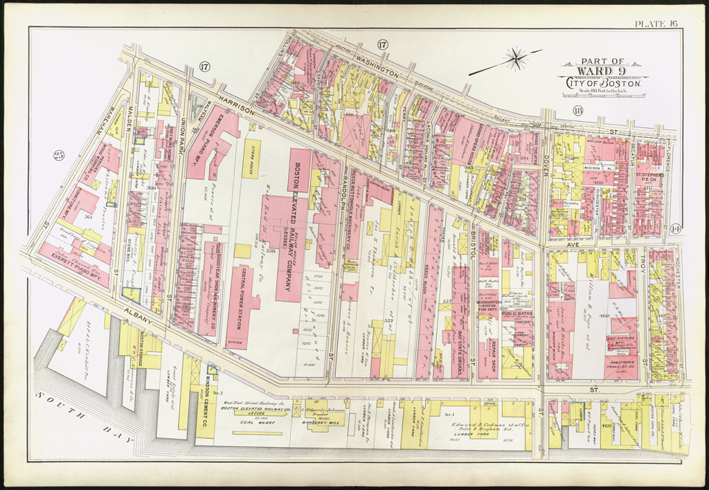
| dc.description | page, Plate 16: part of ward 9; scale 80 feet to the inch; South End, Albany Street, Harrison Avenue, Washington Street | en_US |
| dc.format.medium | paper (fiber product) | en_US |
| dc.format.medium | ink | en_US |
| dc.relation.ispartof | 142985 | en_US |
| dc.subject | Cartography | en_US |
| dc.subject | Urban planning | en_US |
| dc.subject | Boston (Mass.) | en_US |
| dc.subject | Atlases | en_US |
| dc.subject | United States -- Maps | en_US |
| dc.subject | Fire insurance maps | en_US |
| dc.subject | Historical geography --Maps | en_US |
| dc.subject | City planning | en_US |
| dc.subject | South End (Boston, Mass.) | en_US |
| dc.title | Atlas of the City of Boston, Boston Proper and Back Bay, from Actual Surveys and Official Plans (1902) | en_US |
| dc.type | Image | en_US |
| dc.publisher.institution | Repository: Rotch Library, Massachusetts Institute of Technology (Cambridge, Massachusetts, United States) | en_US |
| vra.culturalContext | American | en_US |
| vra.technique | printing | en_US |
| vra.worktype | Atlas | en_US |
| dc.contributor.display | civil engineers: G.W. Bromley & Co. (American, founded late 19th century) | en_US |