MIT Libraries logoDome

MIT
View Item 
  • Dome Home
  • Visual Collections
  • Aga Khan Visual Archive
  • View Item
  • Dome Home
  • Visual Collections
  • Aga Khan Visual Archive
  • View Item
JavaScript is disabled for your browser. Some features of this site may not work without it.

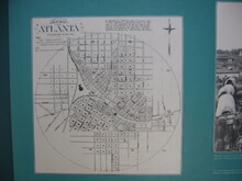
Vincent's subdivision map of the city of Atlanta, Dekalb County, state of Georgia : showing all the lots, blocks, sections, &c.

Vincent, Edward A.
Thumbnail
Download135078_cp.jpg (324.4Kb)
Alternate file
135078_sv.jpg (448.0Kb)
135078_tm.jpg (11.15Kb)
URI
http://hdl.handle.net/1721.3/81325
Date
1850-1859
Description
comparative material, reproduction of map in Atlanta Underground Visitors' Center, 2003
Type of Work
Map
Subject
Cartography, Historical geography --Maps, City planning, Atlanta (Ga.), Cadastral maps
Rights
(c) Özgür Basak Alkan 2003
Rights Statement
All rights reserved
Item is Part of
138607
Metadata
Show full item record

Collections
  • Aga Khan Visual Archive

Browse

All of DomeCommunities & CollectionsBy Issue DateCreatorsTitlesSubjectsThis CollectionBy Issue DateCreatorsTitlesSubjects

My Account

Login
MIT Libraries
PrivacyPermissionsAccessibilityContact us
MIT
Content created by the MIT Libraries, CC BY-NC unless otherwise noted. Notify us about copyright concerns.