MIT Libraries logoDome

MIT
View Item 
  • Dome Home
  • Visual Collections
  • Aerial Photography
  • View Item
  • Dome Home
  • Visual Collections
  • Aerial Photography
  • View Item
JavaScript is disabled for your browser. Some features of this site may not work without it.

City of New Orleans

American
Thumbnail
Download160137_cp.jpg (478.5Kb)
Alternate file
160137_sv.jpg (1.467Mb)
160137_tm.jpg (24.75Kb)
URI
http://hdl.handle.net/1721.3/64272
Date
1718
Description
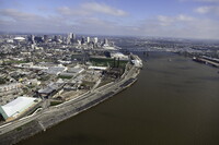
aerial view, view north, central business district and Crescent City Connection (also known as the 'CCC' and formerly known as the Greater New Orleans Bridge) in distance, March 1, 2011
Type of Work
City
Subject
Urban planning, Cities and towns, Louisiana, Louisiana Purchase, Land use, Urban, Architecture, American, Warehouses, Aerial views, Smokestacks, High-rise buildings, Mississippi River, Central business districts, Wharves, Aerial photography --United States, Crescent City Connection, Cantilever bridges, Port of New Orleans
Rights
© Alex S. MacLean / Landslides
Rights Statement
Licensed for educational and research use by the MIT community only
Item is Part of
128945
Metadata
Show full item record

Collections
  • Aerial Photography

Browse

All of DomeCommunities & CollectionsBy Issue DateCreatorsTitlesSubjectsThis CollectionBy Issue DateCreatorsTitlesSubjects

My Account

Login
MIT Libraries
PrivacyPermissionsAccessibilityContact us
MIT
Content created by the MIT Libraries, CC BY-NC unless otherwise noted. Notify us about copyright concerns.