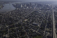
City of New Orleans
American

Download160161_cp.jpg (627.5Kb)
Date
1718Description
aerial view, view southwest from over U.S. 10 and the French Quarter to the central business district, March 1, 2011
Type of Work
CitySubject
Urban planning, Cities and towns, Louisiana, Louisiana Purchase, Land use, Urban, Architecture, American, Highways, Aerial views, Skylines, Mississippi River, Vacant lots, Central business districts, Cityscapes, Interstate 10, French Quarter (New Orleans, La.), Elevated roads, Aerial photography --United States, Shotgun houses
Rights
Rights Statement
Licensed for educational and research use by the MIT community only
Item is Part of
128945