MIT Libraries logoDome

MIT
View Item 
  • Dome Home
  • Visual Collections
  • Aerial Photography
  • View Item
  • Dome Home
  • Visual Collections
  • Aerial Photography
  • View Item
JavaScript is disabled for your browser. Some features of this site may not work without it.

City of Baltimore

American
Thumbnail
Download157312_cp.jpg (960.1Kb)
Alternate file
157312_sv.jpg (1.163Mb)
157312_tm.jpg (22.91Kb)
URI
http://hdl.handle.net/1721.3/60900
Date
1729
Description
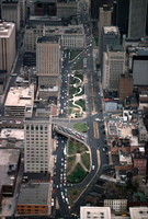
aerial view, downtown, view south along St. Paul Place and St. Paul Street (and current and/or future Preston Gardens Park), April 1978
Type of Work
City
Subject
Urban planning, Ports, Land use, Urban, City planning, Cities and towns -- United States, Parks, Skyscrapers, Walkways, Central business districts, Traffic intersections, Overpasses
Rights
© Alex S. MacLean / Landslides
Rights Statement
Licensed for educational and research use by the MIT community only
Item is Part of
137926
Metadata
Show full item record

Collections
  • Aerial Photography

Browse

All of DomeCommunities & CollectionsBy Issue DateCreatorsTitlesSubjectsThis CollectionBy Issue DateCreatorsTitlesSubjects

My Account

Login
MIT Libraries
PrivacyPermissionsAccessibilityContact us
MIT
Content created by the MIT Libraries, CC BY-NC unless otherwise noted. Notify us about copyright concerns.