| dc.coverage.spatial | Site: Baltimore (Maryland, United States) | en_US |
| dc.creator | American | en_US |
| dc.date.accessioned | 2011-03-03T15:30:44Z | |
| dc.date.available | 2011-03-03T15:30:44Z | |
| dc.date.issued | 1729 | |
| dc.identifier | 157310 | en_US |
| dc.identifier.uri | http://hdl.handle.net/1721.3/60890 | en_US |
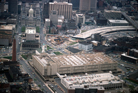
| dc.description | aerial view, downtown, looking west, with Baltimore City Hall in upper left, Phoenix Shot Tower (built 1828, tallest building in U.S. until 1846) at middle left and unfinished end of I 83 in center, April 1978 | en_US |
| dc.relation.ispartof | 137926 | en_US |
| dc.rights | © Alex S. MacLean / Landslides | en_US |
| dc.subject | Urban planning | en_US |
| dc.subject | Ports | en_US |
| dc.subject | Land use, Urban | en_US |
| dc.subject | City planning | en_US |
| dc.subject | Cities and towns -- United States | en_US |
| dc.subject | City halls | en_US |
| dc.subject | Towers | en_US |
| dc.subject | Post offices | en_US |
| dc.subject | Parking lots | en_US |
| dc.subject | Parking garages | en_US |
| dc.subject | Central business districts | en_US |
| dc.subject | Construction equipment | en_US |
| dc.subject | Express highways | en_US |
| dc.title | City of Baltimore | en_US |
| dc.type | Image | en_US |
| dc.rights.access | Licensed for educational and research use by the MIT community only | en_US |
| dc.identifier.vendorcode | 455-12 | en_US |
| vra.culturalContext | American | en_US |
| vra.technique | construction | en_US |
| vra.worktype | City | en_US |
| dc.contributor.display | American | en_US |


