MIT Libraries logoDome

MIT
View Item 
  • Dome Home
  • Visual Collections
  • Aerial Photography
  • View Item
  • Dome Home
  • Visual Collections
  • Aerial Photography
  • View Item
JavaScript is disabled for your browser. Some features of this site may not work without it.

City of Baltimore

American
Thumbnail
Download157336_cp.jpg (1.114Mb)
Alternate file
157336_sv.jpg (1.419Mb)
157336_tm.jpg (24.49Kb)
URI
http://hdl.handle.net/1721.3/60886
Date
1729
Description
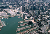
aerial view, Baltimore Inner Harbor, looking northwest, April 1978
Type of Work
City
Subject
Urban planning, Ports, Land use, Urban, City planning, Cities and towns -- United States, Harbors, Piers, Central business districts, Marinas, Waterfronts, Inner Harbor (Baltimore, Md.), Chesapeake Bay (Md. and Va.)
Rights
© Alex S. MacLean / Landslides
Rights Statement
Licensed for educational and research use by the MIT community only
Item is Part of
137926
Metadata
Show full item record

Collections
  • Aerial Photography

Browse

All of DomeCommunities & CollectionsBy Issue DateCreatorsTitlesSubjectsThis CollectionBy Issue DateCreatorsTitlesSubjects

My Account

Login
MIT Libraries
PrivacyPermissionsAccessibilityContact us
MIT
Content created by the MIT Libraries, CC BY-NC unless otherwise noted. Notify us about copyright concerns.