MIT Libraries logoDome

MIT
View Item 
  • Dome Home
  • Visual Collections
  • Aerial Photography
  • View Item
  • Dome Home
  • Visual Collections
  • Aerial Photography
  • View Item
JavaScript is disabled for your browser. Some features of this site may not work without it.

Town of Lincoln

American
Thumbnail
Download154432_cp.jpg (1.422Mb)
Alternate file
154432_sv.jpg (4.753Mb)
154432_tm.jpg (36.28Kb)
154432.tif (18.50Mb)
URI
http://hdl.handle.net/1721.3/57946
Description
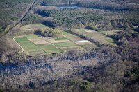
aerial view, agricultural fields of the Food Project, on Baker Bridge Road, 4/14/2006
Type of Work
Town
Subject
Suburbs, Urban planning, Massachusetts, Land use, Urban, Cities and towns -- United States, Farms, Aerial views, Agriculture, Aerial photography --United States, Community gardens, Vegetable gardening
Rights
© Alex S. MacLean / Landslides
Rights Statement
Licensed for educational and research use by the MIT community only
Item is Part of
140593
Metadata
Show full item record

Collections
  • Aerial Photography

Browse

All of DomeCommunities & CollectionsBy Issue DateCreatorsTitlesSubjectsThis CollectionBy Issue DateCreatorsTitlesSubjects

My Account

Login
MIT Libraries
PrivacyPermissionsAccessibilityContact us
MIT
Content created by the MIT Libraries, CC BY-NC unless otherwise noted. Notify us about copyright concerns.