| dc.coverage.spatial | Site: Veneto (Italy) | en_US |
| dc.coverage.temporal | creation date: called S. Nicolò Porto Tolle by official decree, 1867 | en_US |
| dc.creator | Italian | en_US |
| dc.date | 1867 | en_US |
| dc.date.accessioned | 2010-11-19T21:35:05Z | |
| dc.date.available | 2010-11-19T21:35:05Z | |
| dc.date.issued | 1867 | en_US |
| dc.identifier | 149473 | en_US |
| dc.identifier.uri | http://hdl.handle.net/1721.3/57873 | en_US |
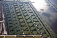
| dc.description | aerial view, rows of round aquaculture eel ponds dug into lagoon wetlands, 9/29/2009 | en_US |
| dc.relation.ispartof | 140277 | en_US |
| dc.rights | © Alex S. MacLean / Landslides | en_US |
| dc.subject | Urban planning | en_US |
| dc.subject | Land use, Urban | en_US |
| dc.subject | Cities and towns -- Italy | en_US |
| dc.subject | City planning -- Italy | en_US |
| dc.subject | Veneto (Italy) | en_US |
| dc.subject | Canals | en_US |
| dc.subject | Geometric patterns | en_US |
| dc.subject | Eels | en_US |
| dc.subject | Aerial photography -- Italy | en_US |
| dc.subject | Aquaculture | en_US |
| dc.subject | Wetlands | en_US |
| dc.title | Town of Porto Tolle | en_US |
| dc.type | Image | en_US |
| dc.rights.access | Licensed for educational and research use by the MIT community only | en_US |
| dc.identifier.vendorcode | 090929-0323 | en_US |
| vra.culturalContext | Italian | en_US |
| vra.technique | construction | en_US |
| vra.worktype | Town | en_US |
| dc.contributor.display | Italian | en_US |


