City of Boston
| dc.coverage.spatial | Site: Boston (Massachusetts, USA) | en_US |
| dc.coverage.temporal | creation date: founded by Puritan colonists, 1630, other date: incorporated as a city, 2314 | en_US |
| dc.creator | American | en_US |
| dc.date | 1630 | en_US |
| dc.date.accessioned | 2010-11-16T16:03:03Z | |
| dc.date.available | 2010-11-16T16:03:03Z | |
| dc.date.issued | 1630 | en_US |
| dc.identifier | 153255 | en_US |
| dc.identifier.uri | http://hdl.handle.net/1721.3/57733 | en_US |
| dc.description | aerial view, Seaport District, with Fort Point Channel and downtown, 10/10/2010 | en_US |
| dc.relation.ispartof | 101195 | en_US |
| dc.rights | © Alex S. MacLean / Landslides | en_US |
| dc.subject | New England | en_US |
| dc.subject | Urban planning | en_US |
| dc.subject | Boston (Mass.) | en_US |
| dc.subject | Cities and towns --Growth | en_US |
| dc.subject | Land use, Urban | en_US |
| dc.subject | City planning | en_US |
| dc.subject | Aerial views | en_US |
| dc.subject | South Boston (Boston, Mass.) | en_US |
| dc.subject | Fort Point Channel Area (Boston, Mass.) | en_US |
| dc.subject | Aerial photography --United States | en_US |
| dc.title | City of Boston | en_US |
| dc.title.alternative | Shawmutt | en_US |
| dc.type | Image | en_US |
| dc.rights.access | Licensed for educational and research use by the MIT community only | en_US |
| dc.identifier.vendorcode | 101010-0110.tif | en_US |
| vra.culturalContext | American | en_US |
| vra.culturalContext | British | en_US |
| vra.worktype | City | en_US |
| dc.contributor.display | American | en_US |
Files in this item


This item appears in the following Collection(s)
-
Aerial Photography
Aerial Photography
Related items
Showing items related by title, author, creator and subject.
-
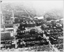
Aerial View Looking South, Copley Square, South End
(Repository: Rotch Visual Collections, Massachusetts Institute of Technology (Cambridge, Massachusetts, United States) ID: Kepes/Lynch Collection, 40.28, 1957) -
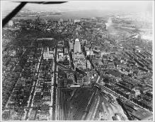
Aerial View from Plane, Looking East, Boylston Street to Intersection with Huntington Avenue, Large Rail Yard, John Hancock Building, Boston Skyline and Harbor in Background
(Repository: Rotch Visual Collections, Massachusetts Institute of Technology (Cambridge, Massachusetts, United States) ID: Kepes/Lynch Collection, 40.06, 1957) -
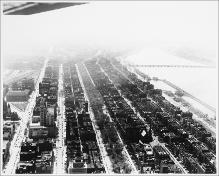
Aerial View, Back Bay, Copley Square, Looking Southwest, Commonwealth Avenue, Charles River
(Repository: Rotch Visual Collections, Massachusetts Institute of Technology (Cambridge, Massachusetts, United States) ID: Kepes/Lynch Collection, 40.09, 1957)