| dc.coverage.spatial | Site: Trier (Germany) | en_US |
| dc.coverage.temporal | Creation date: ca. 15 BCE-ca. 500 CE | en_US |
| dc.creator | unknown (Roman (ancient)) | en_US |
| dc.date | ca. 15 BCE-ca. 500 CE | en_US |
| dc.date.accessioned | 2006-09-29T15:36:06Z | |
| dc.date.available | 2006-09-29T15:36:06Z | |
| dc.date.issued | 15-500 | en_US |
| dc.identifier | 101299 | en_US |
| dc.identifier.uri | http://hdl.handle.net/1721.3/5542 | en_US |
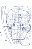
| dc.description | plan (drawing), the bridge and street plan are of the first century CE, the walls and most of the major monuments are of the late third and fourth centuries | en_US |
| dc.relation.ispartof | 127148 | en_US |
| dc.subject | Urban planning | en_US |
| dc.subject | Imperial (Roman) | en_US |
| dc.subject | Cities and towns --Growth | en_US |
| dc.subject | Land use, Urban | en_US |
| dc.subject | Architecture, Ancient | en_US |
| dc.subject | Architecture, Roman | en_US |
| dc.subject | Military towns | en_US |
| dc.subject | Rome --Colonies | en_US |
| dc.subject | Trier (Germany) | en_US |
| dc.title | Plan of Trier (Augusta Treverorum) | en_US |
| dc.type | Image | en_US |
| dc.rights.access | All rights reserved | en_US |
| vra.culturalContext | Roman | en_US |
| vra.worktype | City | en_US |
| vra.worktype | Plan (map) | en_US |
| dc.contributor.display | unknown (Roman (ancient)) | en_US |


