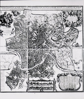
Falda Plan of Rome
| dc.coverage.spatial | Site: Rome (Italy) | en_US |
| dc.coverage.temporal | Creation date: 1676 | en_US |
| dc.creator | Falda, Giovanni Battista | en_US |
| dc.date | 1676 | en_US |
| dc.date.accessioned | 2006-09-22T05:40:58Z | |
| dc.date.available | 2006-09-22T05:40:58Z | |
| dc.date.issued | 1676 | en_US |
| dc.identifier | 101807 | en_US |
| dc.identifier.uri | http://hdl.handle.net/1721.3/5193 | en_US |
| dc.description | full view | en_US |
| dc.format.medium | ink | en_US |
| dc.relation.ispartof | 102920 | en_US |
| dc.subject | Cartography | en_US |
| dc.subject | Rome (Italy) | en_US |
| dc.subject | Urban planning | en_US |
| dc.subject | Historical geography --Maps | en_US |
| dc.subject | Cities and towns --Growth | en_US |
| dc.subject | Land use, Urban | en_US |
| dc.subject | Architecture, Italian | en_US |
| dc.title | Falda Plan of Rome | en_US |
| dc.type | Image | en_US |
| dc.rights.access | All rights reserved | en_US |
| vra.culturalContext | Italian | en_US |
| vra.technique | etching (printing process) | en_US |
| vra.worktype | Historical map | en_US |
| dc.contributor.display | cartographer: Giovanni Battista Falda (Italian, 1640-1678) | en_US |
Files in this item
This item appears in the following Collection(s)
-
Architecture, Urban Planning, and Visual Arts
Online Image Collection


