MIT Libraries logoDome

MIT
View Item 
  • Dome Home
  • Visual Collections
  • Aerial Photography
  • View Item
  • Dome Home
  • Visual Collections
  • Aerial Photography
  • View Item
JavaScript is disabled for your browser. Some features of this site may not work without it.

Clark County

American
Thumbnail
Download140025_cp.jpg (887.1Kb)
Alternate file
140025_sv.jpg (2.923Mb)
140025_tm.jpg (23.89Kb)
URI
http://hdl.handle.net/1721.3/50563
Date
1909
Description
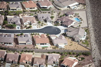
aerial view, section of a subdivision on a cul de sac surrounded by a high wall, 9 larger houses, October 26, 2009
Type of Work
County
Subject
Deserts, Southwest (U.S.), Nevada, Land use, Urban, City planning, Counties, Fences, Aerial views, Walls, Housing developments, Aerial photography --United States, Single-family dwellings, Xeriscapes
Rights
© Alex S. MacLean / Landslides
Rights Statement
Licensed for educational and research use by the MIT community only
Item is Part of
139186
Metadata
Show full item record

Collections
  • Aerial Photography

Browse

All of DomeCommunities & CollectionsBy Issue DateCreatorsTitlesSubjectsThis CollectionBy Issue DateCreatorsTitlesSubjects

My Account

Login
MIT Libraries
PrivacyPermissionsAccessibilityContact us
MIT
Content created by the MIT Libraries, CC BY-NC unless otherwise noted. Notify us about copyright concerns.