MIT Libraries logoDome

MIT
View Item 
  • Dome Home
  • Visual Collections
  • Aerial Photography
  • View Item
  • Dome Home
  • Visual Collections
  • Aerial Photography
  • View Item
JavaScript is disabled for your browser. Some features of this site may not work without it.

Clark County

American
Thumbnail
Download140024_cp.jpg (529.8Kb)
Alternate file
140024_sv.jpg (1.547Mb)
140024_tm.jpg (20.66Kb)
URI
http://hdl.handle.net/1721.3/50562
Date
1909
Description
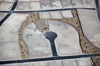
aerial view, cul de sac in a housing development with only one house built, partitioned lots with a grid of streets in place, October 26, 2009
Type of Work
County
Subject
Deserts, Southwest (U.S.), Nevada, Land use, Urban, City planning, Counties, Planned communities, Aerial views, Walls, Culs-de-sac, Aerial photography --United States, Lots (land), Xeriscapes
Rights
© Alex S. MacLean / Landslides
Rights Statement
Licensed for educational and research use by the MIT community only
Item is Part of
139186
Metadata
Show full item record

Collections
  • Aerial Photography

Browse

All of DomeCommunities & CollectionsBy Issue DateCreatorsTitlesSubjectsThis CollectionBy Issue DateCreatorsTitlesSubjects

My Account

Login
MIT Libraries
PrivacyPermissionsAccessibilityContact us
MIT
Content created by the MIT Libraries, CC BY-NC unless otherwise noted. Notify us about copyright concerns.