MIT Libraries logoDome

MIT
View Item 
  • Dome Home
  • Visual Collections
  • Aerial Photography
  • View Item
  • Dome Home
  • Visual Collections
  • Aerial Photography
  • View Item
JavaScript is disabled for your browser. Some features of this site may not work without it.

Clark County

American
Thumbnail
Download140005_cp.jpg (919.4Kb)
Alternate file
140005_sv.jpg (3.077Mb)
140005_tm.jpg (21.36Kb)
URI
http://hdl.handle.net/1721.3/50543
Date
1909
Description
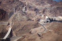
aerial view, new highway and bridges under construction to bypass Hoover Dam in part for national security reasons , October 26, 2009
Type of Work
County
Subject
Deserts, Southwest (U.S.), Nevada, Land use, Urban, City planning, Counties, Bridges, Dams, Highways, Aerial views, Hoover Dam (Ariz. and Nev.), Overpasses, Aerial photography --United States, Construction sites, Lake Mead (Ariz. and Nev.), National security--United States
Rights
© Alex S. MacLean / Landslides
Rights Statement
Licensed for educational and research use by the MIT community only
Item is Part of
139186
Metadata
Show full item record

Collections
  • Aerial Photography

Browse

All of DomeCommunities & CollectionsBy Issue DateCreatorsTitlesSubjectsThis CollectionBy Issue DateCreatorsTitlesSubjects

My Account

Login
MIT Libraries
PrivacyPermissionsAccessibilityContact us
MIT
Content created by the MIT Libraries, CC BY-NC unless otherwise noted. Notify us about copyright concerns.