| dc.coverage.spatial | Site: Boston (Massachusetts, USA) | en_US |
| dc.coverage.temporal | creation date: founded by Puritan colonists, 1630, other date: incorporated as a city, 1957 | en_US |
| dc.creator | American | en_US |
| dc.date | 1630 | en_US |
| dc.date.accessioned | 2010-01-08T21:23:32Z | |
| dc.date.available | 2010-01-08T21:23:32Z | |
| dc.date.issued | 1630 | en_US |
| dc.identifier | 136074 | en_US |
| dc.identifier.other | 101195 | en_US |
| dc.identifier.uri | http://hdl.handle.net/1721.3/46757 | |
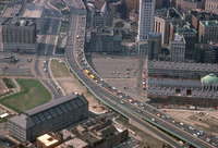
| dc.description | aerial view, I-93 (Central Artery); Faneuil Hall, May 1978 | en_US |
| dc.subject.lcsh | Boston (Mass.) | en_US |
| dc.subject.lcsh | Cities and towns --Growth | en_US |
| dc.subject.lcsh | Land use, Urban | en_US |
| dc.subject.lcsh | City planning | en_US |
| dc.subject.lcsh | Faneuil Hall (Boston, Mass.) | en_US |
| dc.subject.lcsh | Aerial photography --United States | en_US |
| dc.subject.other | New England | en_US |
| dc.subject.other | Urban planning | en_US |
| dc.subject.other | Highways | en_US |
| dc.subject.other | Aerial views | en_US |
| dc.title | City of Boston | en_US |
| dc.title.alternative | City of Boston | en_US |
| dc.title.alternative | Shawmutt | en_US |
| dc.type | City | en_US |
| dc.rights.copyright | © Alex S. MacLean / Landslides | en_US |
| dc.rights.access | Licensed for educational and research use by the MIT community only | en_US |
| dc.identifier.vendorcode | LS_0480_35 | en_US |
| dc.contributor.display | American | en_US |