MIT Libraries logoDome

MIT
View Item 
  • Dome Home
  • Visual Collections
  • Aerial Photography
  • View Item
  • Dome Home
  • Visual Collections
  • Aerial Photography
  • View Item
JavaScript is disabled for your browser. Some features of this site may not work without it.

City of Boston

American
Thumbnail
Download130217_cp.jpg (956.4Kb)
Alternate file
130217_sv.jpg (2.873Mb)
130217_tm.jpg (20.40Kb)
130217.tif (18.02Mb)
Alternative Title
Shawmutt
URI
http://hdl.handle.net/1721.3/44371
Date
1630
Description
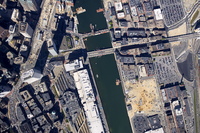
aerial view, Downtown, South Station, Fort Point Channel, 8/26/2004
Type of Work
City
Subject
New England, Urban planning, Boston (Mass.), Cities and towns --Growth, Land use, Urban, City planning, Aerial views, Parking lots, Central business districts, Fort Point Channel Area (Boston, Mass.), Aerial photography --United States
Rights
© Alex S. MacLean / Landslides
Rights Statement
Licensed for educational and research use by the MIT community only
Item is Part of
101195
Metadata
Show full item record

Collections
  • Aerial Photography

Browse

All of DomeCommunities & CollectionsBy Issue DateCreatorsTitlesSubjectsThis CollectionBy Issue DateCreatorsTitlesSubjects

My Account

Login
MIT Libraries
PrivacyPermissionsAccessibilityContact us
MIT
Content created by the MIT Libraries, CC BY-NC unless otherwise noted. Notify us about copyright concerns.