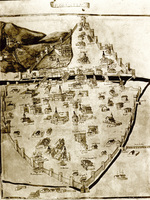
| dc.coverage.temporal | creation date: 1472 | en_US |
| dc.creator | Del Massaio, Pietro | en_US |
| dc.date | 1472 | en_US |
| dc.date.accessioned | 2009-03-27T14:20:35Z | |
| dc.date.available | 2009-03-27T14:20:35Z | |
| dc.date.issued | 1472 | en_US |
| dc.identifier | 126048 | en_US |
| dc.identifier.uri | http://hdl.handle.net/1721.3/36897 | en_US |
| dc.description | Cod. Vaticano-Urbinate n. 277 | en_US |
| dc.description | map | en_US |
| dc.format.medium | paper (fiber product) | en_US |
| dc.format.medium | ink | en_US |
| dc.relation.ispartof | 136062 | en_US |
| dc.subject | Florence (Italy) | en_US |
| dc.subject | Italy | en_US |
| dc.subject | Maps | en_US |
| dc.subject | Cities and towns | en_US |
| dc.subject | Plans (drawings) | en_US |
| dc.subject | Historical geography --Maps | en_US |
| dc.subject | Land use, Urban | en_US |
| dc.subject | City planning | en_US |
| dc.title | Florentia, Iconographic Map of the City of Florence | en_US |
| dc.title.alternative | Geographia | en_US |
| dc.type | Image | en_US |
| dc.rights.access | All rights reserved | en_US |
| dc.publisher.institution | Repository: Biblioteca apostolica vaticana (Vatican City, Vatican City) | en_US |
| vra.culturalContext | Italian | en_US |
| vra.technique | drawing (image-making) | en_US |
| vra.worktype | Map | en_US |
| dc.contributor.display | cartographer: Pietro Del Massaio (Italian, active late 15th century) | en_US |


