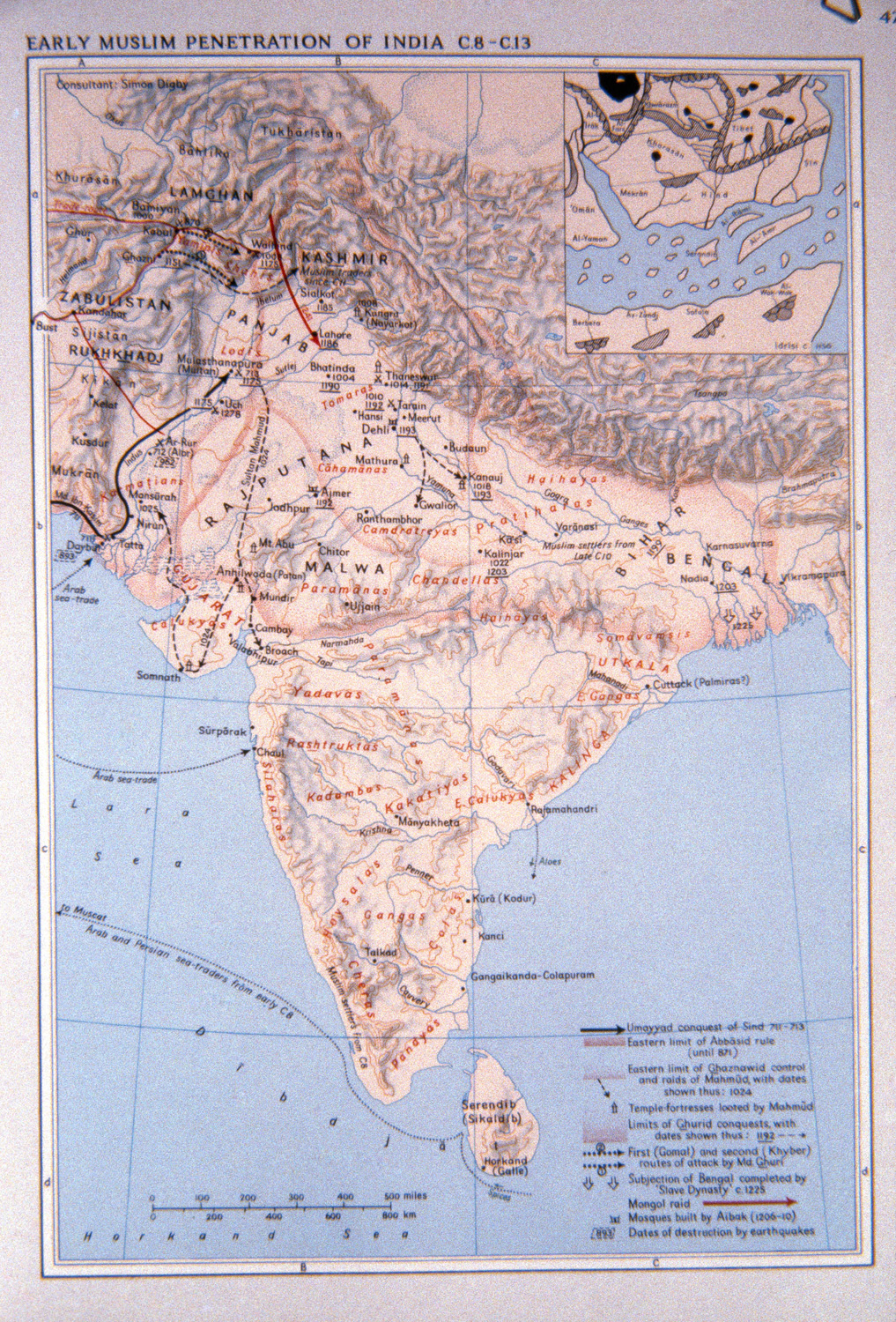
| dc.coverage.temporal | other date: dates depicted in map, 8th-13th centuries, creation date: ca. 1981 | en_US |
| dc.creator | Unknown | en_US |
| dc.date.accessioned | 2009-03-03T15:31:30Z | |
| dc.date.available | 2009-03-03T15:31:30Z | |
| dc.identifier | 125686 | en_US |
| dc.identifier.uri | http://hdl.handle.net/1721.3/36576 | en_US |
| dc.description | full view | en_US |
| dc.format.medium | paper (fiber product) | en_US |
| dc.format.medium | ink | en_US |
| dc.relation.ispartof | 136909 | en_US |
| dc.rights | map (c) E.J. Brill, Leiden, The Netherlands, image (c) Prataap Patrose, Courtesy of the Aga Khan Visual Archive, MIT | en_US |
| dc.subject | Cartography | en_US |
| dc.subject | Islam -- History | en_US |
| dc.subject | Umayyad dynasty | en_US |
| dc.subject | Abbasid | en_US |
| dc.subject | Ghaznavid | en_US |
| dc.subject | Ghurid | en_US |
| dc.subject | Islamic Empire | en_US |
| dc.subject | Historical geography --Maps | en_US |
| dc.subject | Topographic maps | en_US |
| dc.subject | Islamic countries -- Maps | en_US |
| dc.subject | India -- Maps | en_US |
| dc.title | Early Muslim Penetration Of India, C8- C13 | en_US |
| dc.title.alternative | Early Muslim Penetration Of India, 8th to 13th Centuries | en_US |
| dc.type | Image | en_US |
| dc.rights.access | All rights reserved | en_US |
| dc.identifier.vendorcode | 43-20 | en_US |
| vra.culturalContext | Indian (South Asian) | en_US |
| vra.culturalContext | Islamic | en_US |
| vra.technique | cartography | en_US |
| vra.worktype | Map | en_US |
| dc.contributor.display | Indian (South Asian), Islamic | en_US |