Thailand: Experimental Satellite Photomap
Download126143_cp.jpg (136.0Kb)
Date
1972-1973Description
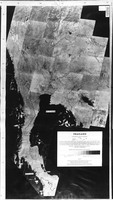
full view, Assembled from pictures produced at an altitude of 914 km by the first NASA Earth Resources Technology Satellite (ERTS-1) during the period October 1972 to March 1973. Image were reconstructed from magnetic tape recordings of data received by the ERTS-1 multispectral scanner in near-infrared band 7 (0.8-1.1 micron wavelength band)
Type of Work
PhotomapSubject
Cartography, Thailand, Thailand--Remote-sensing maps, Landsat satellites, Earth resources technology satellites
Rights Statement
All rights reserved
Item is Part of
136927