Browsing Perceptual Form of the City by Subject "Aerial Views of Boston, (Boston, MA)"
Now showing items 1-20 of 48
-
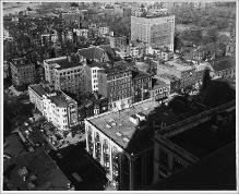
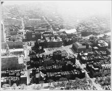
Aerial View from John Hancock Building, Berkeley Street, Surrounding City Blocks, Boston Public Garden in Distance
(Repository: Rotch Visual Collections, Massachusetts Institute of Technology (Cambridge, Massachusetts, United States) ID: Kepes/Lynch Collection, 40.02, 1954-1959) -
Aerial View from John Hancock Building, Berkeley Street, Surrounding City Blocks, Charles River in Distance
(Repository: Rotch Visual Collections, Massachusetts Institute of Technology (Cambridge, Massachusetts, United States) ID: Kepes/Lynch Collection, 40.03, 1957) -
Aerial View from John Hancock Building, Looking Northeast, Boston Common and Public Gardens, St. James Avenue and Arlington Street Church, State House in Background, 3:00 P.M.
(Repository: Rotch Visual Collections, Massachusetts Institute of Technology (Cambridge, Massachusetts, United States) ID: Kepes/Lynch Collection, 40.10, 1954-1959) -
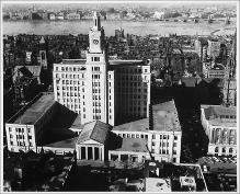
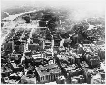
Aerial View from John Hancock Building, of New England Mutual building, Charles River, Longfellow Bridge in Background
(Repository: Rotch Visual Collections, Massachusetts Institute of Technology (Cambridge, Massachusetts, United States) ID: Kepes/Lynch Collection, 40.01, 1954-1959) -
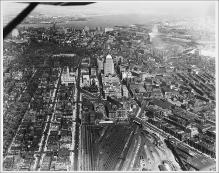
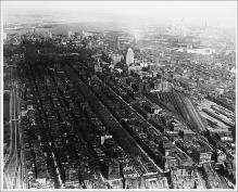
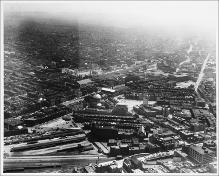
Aerial View from Plane, Looking East, Boylston Street to Intersection with Huntington Avenue, Large Rail Yard, John Hancock Building, Boston Skyline and Harbor in Background
(Repository: Rotch Visual Collections, Massachusetts Institute of Technology (Cambridge, Massachusetts, United States) ID: Kepes/Lynch Collection, 40.06, 1957) -
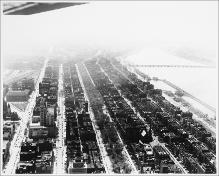
Aerial View Looking East, Back Bay from Massachusetts Avenue and Commonwealth Avenue, to Public Gardens and Boston Inner Harbor, Logan Airport in Far Distance
(Repository: Rotch Visual Collections, Massachusetts Institute of Technology (Cambridge, Massachusetts, United States) ID: Kepes/Lynch Collection, 40.25, 1957) -
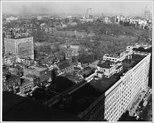
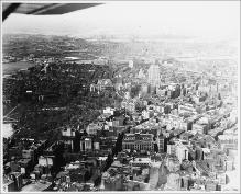
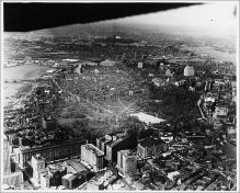
Aerial View Looking North to Boston Common and State House, Charles River and Charlestown in Distance
(Repository: Rotch Visual Collections, Massachusetts Institute of Technology (Cambridge, Massachusetts, United States) ID: Kepes/Lynch Collection, 40.29, 1957) -
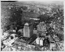
Aerial View Looking North, John Hancock Building, Copley Square and Clarendon Street
(Repository: Rotch Visual Collections, Massachusetts Institute of Technology (Cambridge, Massachusetts, United States) ID: Kepes/Lynch Collection, 40.27, 1957) -
Aerial View Looking Northeast, Boston Common and Gardens, Columbus Avenue and Hotel Statler in Foreground, Beacon Hill, Charles River, Science Museum and Tobin Bridge in Distance
(Repository: Rotch Visual Collections, Massachusetts Institute of Technology (Cambridge, Massachusetts, United States) ID: Kepes/Lynch Collection, 40.36, 1954-1959) -
Aerial View Looking Northeast, Boston Common, State House and West End, Longfellow Bridge, Museum of Science and North Station Area, and Somerville Across the Charles River in Distance
(Repository: Rotch Visual Collections, Massachusetts Institute of Technology (Cambridge, Massachusetts, United States) ID: Kepes/Lynch Collection, 40.26, 1957) -
Aerial View Looking Northeast, John Hancock Building, Boston Common, State House, Water in Distance
(Repository: Rotch Visual Collections, Massachusetts Institute of Technology (Cambridge, Massachusetts, United States) ID: Kepes/Lynch Collection, 40.33, 1954-1959) -
Aerial View Looking South, Boylston Street with Bridge over Railroad Tracks, Christian Science Center, Huntington Avenue
(Repository: Rotch Visual Collections, Massachusetts Institute of Technology (Cambridge, Massachusetts, United States) ID: Kepes/Lynch Collection, 40.35, 1954-1959) -
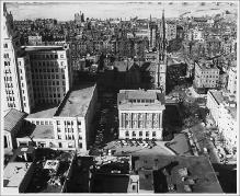
Aerial View Looking South, Copley Square, South End
(Repository: Rotch Visual Collections, Massachusetts Institute of Technology (Cambridge, Massachusetts, United States) ID: Kepes/Lynch Collection, 40.28, 1957) -
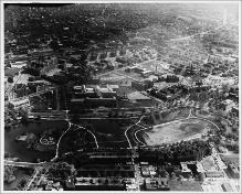
Aerial View Looking South, the Fens, Charlesgate and Boylston Street, Museum of Fine Arts in Distance
(Repository: Rotch Visual Collections, Massachusetts Institute of Technology (Cambridge, Massachusetts, United States) ID: Kepes/Lynch Collection, 40.38, 1954-1959) -
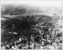
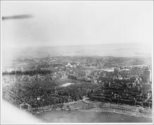
Aerial View Looking Southeast, Charles River, Boston Common and Public Gardens, Harbor Islands and Sea, Hatch Shell and Esplanade in Foreground
(Repository: Rotch Visual Collections, Massachusetts Institute of Technology (Cambridge, Massachusetts, United States) ID: Kepes/Lynch Collection, 40.32, 1954-1959) -
Aerial View Looking Southeast, Park Drive, the Fens, Museum of Fine Arts, Huntington Avenue in Distance
(Repository: Rotch Visual Collections, Massachusetts Institute of Technology (Cambridge, Massachusetts, United States) ID: Kepes/Lynch Collection, 40.37, 1954-1959) -
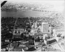
Aerial View, Back Bay, Copley Square, Looking Southwest, Commonwealth Avenue, Charles River
(Repository: Rotch Visual Collections, Massachusetts Institute of Technology (Cambridge, Massachusetts, United States) ID: Kepes/Lynch Collection, 40.09, 1957) -
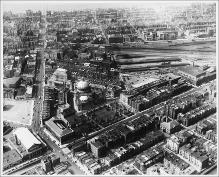
Aerial View, Boston, South Boston, Before Turnpike, Chinatown/Theater District
(Repository: Rotch Visual Collections, Massachusetts Institute of Technology (Cambridge, Massachusetts, United States) ID: Kepes/Lynch Collection, 40.31, 1954-1959) -
Aerial View, Boylston Street, Massachusetts Avenue, Back Bay, Part of Mary Baker Eddy Library, Charles River with Boats, Cambridge and MIT in Distance
(Repository: Rotch Visual Collections, Massachusetts Institute of Technology (Cambridge, Massachusetts, United States) ID: Kepes/Lynch Collection, 40.07, 1957) -
Aerial View, Christian Science Center and South End, Back Bay, Massachusetts Avenue to Charles River, Symphony Hall in Foreground
(Repository: Rotch Visual Collections, Massachusetts Institute of Technology (Cambridge, Massachusetts, United States) ID: Kepes/Lynch Collection, 40.22, 1954-1959)