Browsing Perceptual Form of the City by Subject "Railroads, elevated"
Now showing items 1-20 of 35
-
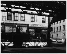
Drug Stores, Kornfield Pharmacy, Corner of Williams and Washington Streets, Elevated Rail at Right
(Repository: Rotch Visual Collections, Massachusetts Institute of Technology (Cambridge, Massachusetts, United States) ID: Kepes/Lynch Collection, 46.06, 1956) -
Drug Stores, Kornfield Pharmacy, Corner of Williams and Washington Streets, View from under Elevated Rail
(Repository: Rotch Visual Collections, Massachusetts Institute of Technology (Cambridge, Massachusetts, United States) ID: Kepes/Lynch Collection, 46.05, 1956) -
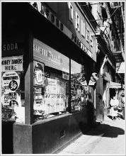
Drug Stores, Sanford Pharmacy, Corner of West Brookline and Washington Streets
(Repository: Rotch Visual Collections, Massachusetts Institute of Technology (Cambridge, Massachusetts, United States) ID: Kepes/Lynch Collection, 46.04, 1956) -
Drug Stores, Sanford Pharmacy, Corner of West Brookline and Washington Streets, View from under Elevated Rail
(Repository: Rotch Visual Collections, Massachusetts Institute of Technology (Cambridge, Massachusetts, United States) ID: Kepes/Lynch Collection, 46.03, 1956) -
Grid Series, Taken from Intersecting Points of Map, Central Artery, Causeway Street, Facing Elevated Rail, 11:30 A.M.
(Repository: Rotch Visual Collections, Massachusetts Institute of Technology (Cambridge, Massachusetts, United States) ID: Kepes/Lynch Collection, 51.03, 1954-1959) -
Grid Series, Taken from Intersecting Points of Map, Massachusetts Avenue, Facing West towards Elevated Rail, 1:50 P.M.
(Repository: Rotch Visual Collections, Massachusetts Institute of Technology (Cambridge, Massachusetts, United States) ID: Kepes/Lynch Collection, 51.10, 1954-1959) -
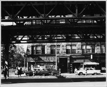
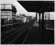
MTA platform above Washington and Dover Streets, looking East across tracks at buildings, one with large South End Hardware sign on two sides
(Repository: Rotch Visual Collections, Massachusetts Institute of Technology (Cambridge, Massachusetts, United States) ID: Kepes/Lynch Collection, 39.04a, 1956) -
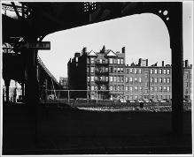
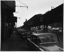
Washington and Castle Streets, looking East, view of row of buildings from under elevated rail
(Repository: Rotch Visual Collections, Massachusetts Institute of Technology (Cambridge, Massachusetts, United States) ID: Kepes/Lynch Collection, 39.03a, 1956) -
Washington and Castle Streets, looking East, view of row of buildings from under elevated rail
(Repository: Rotch Visual Collections, Massachusetts Institute of Technology (Cambridge, Massachusetts, United States) ID: Kepes/Lynch Collection, 39.02, 1956) -
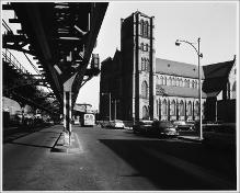
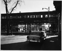
Washington and Dedham Streets, Looking East from Under Elevated Rail at Holy Cross Cathedral
(Repository: Rotch Visual Collections, Massachusetts Institute of Technology (Cambridge, Massachusetts, United States) ID: Kepes/Lynch Collection, 39.11, 1956) -
Washington and Waltham Streets, Corner, Looking East, Under Curving Elevated Rail, Bottled Liquors Sign
(Repository: Rotch Visual Collections, Massachusetts Institute of Technology (Cambridge, Massachusetts, United States) ID: Kepes/Lynch Collection, 39.08b, 1956) -
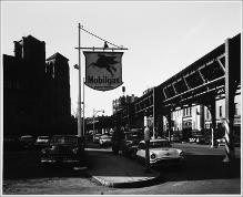
Washington and Waltham Streets, Looking West, Mobilgas Sign with Pegasus Logo, Elevated Rail on Right, Holy Cross Cathedral
(Repository: Rotch Visual Collections, Massachusetts Institute of Technology (Cambridge, Massachusetts, United States) ID: Kepes/Lynch Collection, 39.08a, 1956) -
Washington and Worcester Streets, Looking East, from Under Elevated Rail, Storefronts with Liquor Store at Corner
(Repository: Rotch Visual Collections, Massachusetts Institute of Technology (Cambridge, Massachusetts, United States) ID: Kepes/Lynch Collection, 39.15, 1956) -
Washington at Union Park Street Looking East, Sidewalk, Elevated Rail, Street, Mobilgas Signs, Parked Cars
(Repository: Rotch Visual Collections, Massachusetts Institute of Technology (Cambridge, Massachusetts, United States) ID: Kepes/Lynch Collection, 39.09, 1956) -
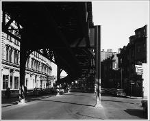
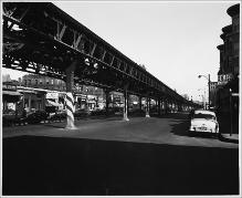
Washington Street (Broadway to Massachusetts Avenue), Looking West, Storefronts on Left, Elevated Rail, Platform, with Shelter and Cupola Above
(Repository: Rotch Visual Collections, Massachusetts Institute of Technology (Cambridge, Massachusetts, United States) ID: Kepes/Lynch Collection, 39.23, 1954-1959) -
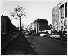
Washington Street (Broadway to Massachusetts Avenue), Two Lane Section, Parked Cars, Curve in Elevated Rail, Supports Span from Sidewalk to Sidewalk, Tall Building on Left, Coffee Shop and Storefronts Across Street
(Repository: Rotch Visual Collections, Massachusetts Institute of Technology (Cambridge, Massachusetts, United States) ID: Kepes/Lynch Collection, 39.21, 1954-1959) -
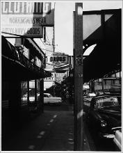
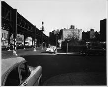
Washington Street and Massachusetts Avenue, Intersection, Silhouette of Elevated Rail, Platform, Pedestrian, Advertising Posters Across Image
(Repository: Rotch Visual Collections, Massachusetts Institute of Technology (Cambridge, Massachusetts, United States) ID: Kepes/Lynch Collection, 39.18, 1956) -
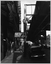
Washington Street at East Springfield Street, Looking East, Diagonally to North Side of Washington Street, Meat Market, Other Stores, Profile View of Elevated Rail
(Repository: Rotch Visual Collections, Massachusetts Institute of Technology (Cambridge, Massachusetts, United States) ID: Kepes/Lynch Collection, 39.16, 1956) -
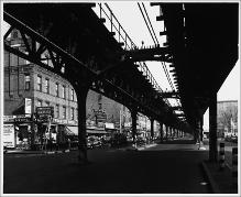
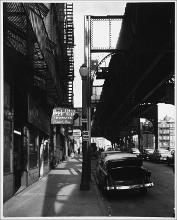
Washington Street looking East, between Castle and Cobbs Streets, view along sidewalk under elevated rail, 10:00 A.M.-1:00 P.M.
(Repository: Rotch Visual Collections, Massachusetts Institute of Technology (Cambridge, Massachusetts, United States) ID: Kepes/Lynch Collection, 39.03, 1954-1959)