| dc.coverage.temporal | creation date: 1984 | en_US |
| dc.creator | National Atlas & Thematic Mapping Organisation (India) | en_US |
| dc.date | 1984 | en_US |
| dc.date.accessioned | 2008-11-17T16:41:51Z | |
| dc.date.available | 2008-11-17T16:41:51Z | |
| dc.date.issued | 1984 | en_US |
| dc.identifier | 125748 | en_US |
| dc.identifier.uri | http://hdl.handle.net/1721.3/29914 | en_US |
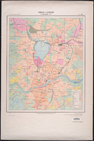
| dc.description | Plate 300; Sources: Government Publications, Census of India, 1971, Survey of India maps and Field Surveys. Printed at teh 104 (HBD) Printing Group of Survey of India. | en_US |
| dc.description | full view | en_US |
| dc.format.extent | 61 x 49 cm (24.02 x 19.29 inches), scale: 1:25,000 cm | en_US |
| dc.format.medium | paper (fiber product) | en_US |
| dc.format.medium | ink | en_US |
| dc.relation.ispartof | 136216 | en_US |
| dc.rights | Government of India | en_US |
| dc.subject | Cartography | en_US |
| dc.subject | Land use, Urban | en_US |
| dc.subject | Hyderabad (India) | en_US |
| dc.subject | Secunderābād (India) | en_US |
| dc.subject | Cities and towns -- India | en_US |
| dc.subject | India -- Maps | en_US |
| dc.title | Urban Landuse, Hyderābād City | en_US |
| dc.title.alternative | Urban Landuse, Hyderabad City | en_US |
| dc.title.alternative | National Atlas of India Plate 300 | en_US |
| dc.type | Image | en_US |
| dc.rights.access | All rights reserved | en_US |
| dc.publisher.institution | Repository: Rotch Library, Massachusetts Institute of Technology (Cambridge, Massachusetts, United States) | en_US |
| vra.culturalContext | Indian (South Asian) | en_US |
| vra.technique | printing | en_US |
| vra.worktype | Map | en_US |
| dc.contributor.display | cartographer: National Atlas & Thematic Mapping Organisation (India) (Indian (South Asian), 1956-) | en_US |


