| dc.creator | Bharat Graphics | en_US |
| dc.date.accessioned | 2008-11-17T16:40:21Z | |
| dc.date.available | 2008-11-17T16:40:21Z | |
| dc.identifier | 125753 | en_US |
| dc.identifier.uri | http://hdl.handle.net/1721.3/29909 | en_US |
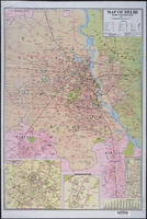
| dc.description | Shows the Union Territory of Delhi and includes portions of Haryana and Uttar Pradesh. Selected buildings shown pictorially. Includes insets of Connaught place, Chanakyapuri, and "Excursions around Delhi", and graph showing monthly temperature and precipitation. | en_US |
| dc.description | full view | en_US |
| dc.format.extent | 70 x 48 cm (27.56 x 18.9 inches), scale: 1:200000 cm | en_US |
| dc.format.medium | paper (fiber product) | en_US |
| dc.format.medium | ink | en_US |
| dc.relation.ispartof | 136233 | en_US |
| dc.rights | Government of India | en_US |
| dc.subject | Cartography | en_US |
| dc.subject | Delhi (India) | en_US |
| dc.subject | Land use, Urban | en_US |
| dc.subject | Cities and towns -- India | en_US |
| dc.subject | India -- Maps | en_US |
| dc.subject | Maps, Tourist | en_US |
| dc.subject | Roads -- Maps | en_US |
| dc.title | Map of Delhi, Political cum Road Map | en_US |
| dc.type | Image | en_US |
| dc.rights.access | All rights reserved | en_US |
| dc.publisher.institution | Repository: Rotch Library, Massachusetts Institute of Technology (Cambridge, Massachusetts, United States) | en_US |
| vra.culturalContext | Indian (South Asian) | en_US |
| vra.technique | printing | en_US |
| vra.worktype | Map | en_US |
| dc.contributor.display | printer: Bharat Graphics (Indian (South Asian), founded ca. 1980-) | en_US |


