| dc.creator | Universität Bonn. Geographisches Institut | en_US |
| dc.creator | Storbeck, Gerd | en_US |
| dc.date.accessioned | 2008-11-17T16:39:42Z | |
| dc.date.available | 2008-11-17T16:39:42Z | |
| dc.identifier | 125744 | en_US |
| dc.identifier.uri | http://hdl.handle.net/1721.3/29906 | en_US |
| dc.description | full view | en_US |
| dc.format.extent | 91.44 x 101.6 cm (36 x 40 inches) | en_US |
| dc.format.medium | paper (fiber product) | en_US |
| dc.format.medium | ink | en_US |
| dc.relation.ispartof | 136185 | en_US |
| dc.rights | Geographische Institute der Universität Bonn | en_US |
| dc.subject | Cartography | en_US |
| dc.subject | Urban planning | en_US |
| dc.subject | Delhi (India) | en_US |
| dc.subject | Copies (derivative objects) | en_US |
| dc.subject | Cities and towns -- India | en_US |
| dc.subject | India -- Maps | en_US |
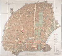
| dc.title | Shāhjahānābād, Delhi around 1850 | en_US |
| dc.title.alternative | Shahjahanabad, Delhi around 1850 | en_US |
| dc.type | Image | en_US |
| dc.rights.access | All rights reserved | en_US |
| dc.publisher.institution | Repository: Rotch Library, Massachusetts Institute of Technology (Cambridge, Massachusetts, United States) | en_US |
| vra.culturalContext | Indian (South Asian) | en_US |
| vra.technique | cartography | en_US |
| vra.worktype | Map | en_US |
| dc.contributor.display | publisher: Universität Bonn. Geographisches Institut, cartographer: Gerd Storbeck (German, born 20th century) | en_US |


