MIT Libraries logoDome

MIT
View Item 
  • Dome Home
  • Visual Collections
  • Aga Khan Visual Archive
  • View Item
  • Dome Home
  • Visual Collections
  • Aga Khan Visual Archive
  • View Item
JavaScript is disabled for your browser. Some features of this site may not work without it.

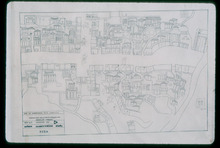
Urban Conservation Study, Map of Hyderabad City

Hyderabad Urban Development Authority
Thumbnail
Download112292_cp.jpg (275.7Kb)
Alternate file
112292_sv.jpg (681.9Kb)
112292_tm.jpg (26.95Kb)
URI
http://hdl.handle.net/1721.3/22072
Date
1772
Description
map, sheet 2, Darush shifa area, 1986
Type of Work
Map
Subject
Cartography, Conservation, Islamic cities and towns, Architecture, Islamic --India, Historical geography --Maps, Urban planning and environment, Hyderabad (India), Deccan (India)
Rights
(c) Rahul Mehrotra 1986
Rights Statement
All rights reserved
Item is Part of
131501
Metadata
Show full item record

Collections
  • Aga Khan Visual Archive

Browse

All of DomeCommunities & CollectionsBy Issue DateCreatorsTitlesSubjectsThis CollectionBy Issue DateCreatorsTitlesSubjects

My Account

Login
MIT Libraries
PrivacyPermissionsAccessibilityContact us
MIT
Content created by the MIT Libraries, CC BY-NC unless otherwise noted. Notify us about copyright concerns.